Sepmeries geodata
Sepmeries (Hauts-de-France) is a populated place; located in France in Europe/Paris (GMT+2) time zone. With population of 534 people, there are 14532 cities with bigger population in this country. Compared to other cities in France, 95.4% of cities are located further ↓South; 64.8% of cities are located further ←West and 71% of cities have higher elevation than Sepmeries. Note1
Administrative division(s):
- Level 1: Hauts-de-France
- Level 2: Nord
- Level 3: Avesnes-sur-Helpe
- Level 4: Sepmeries


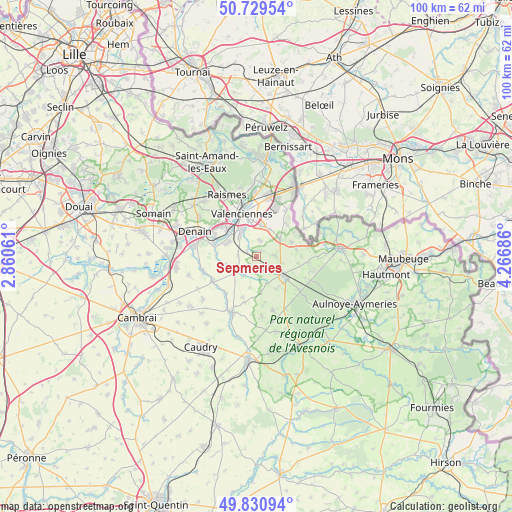
Sepmeries GPS coordinates[2]
50° 16' 56.496" North, 3° 33' 49.428" East
| Map corner | latitude | longitude |
|---|---|---|
| Upper-left | 50.72954°, | 2.86061° |
| Center: | 50.28236°, | 3.56373° |
| Lower-right: | 49.83094°, | 4.26686° |
| Map W x H: | 99.9×99.9 km | = 62.1×62.1mi |
| max Lat: | 51.07786° ⇑4.6% North |
| Sepmeries: | 50.28236° |
| min Lat: | ⇓95.4% South 41.3874° |
| min Long | Sepmeries | max Long |
| -5.08615° | 3.56373° | 9.52242° |
| W 64.8%⇐ | ⇒35.2% E |
Elevation
Elevation of Sepmeries is 76 m = 249 ft, and this is 117.7 m = 386 ft below average elevation for this country.
| Max E: |
2333 m = 7654 ft | 71% |
| Avg. | 193.7 m = 635 ft | |
| Sepmeries | 76 m = 249 ft | |
Min E: |
-1 m = -3 ft | 29% |
See also: France elevation on elevation.city.
Geographical zone
Sepmeries is located in North temperate zone (between Tropic of Cancer and the Arctic Circle). Distance of this North polar circle is 1810.3 km =1124.9 mi to North.| Distance of | km | miles | from Sepmeries |
|---|---|---|---|
| North Pole | 4416.2 | 2744.1 | to North |
| Arctic Circle | 1810.3 | 1124.9 | to North |
| Tropic Cancer | 2985 | 1854.8 | to South |
| Equator | 5590.9 | 3474 | to South |


Nearby cities:
15 places around Sepmeries: (largest is in red/bold)
• Artres
2.2 km =1.4 mi,  309°
309°
• Aulnoy-lez-Valenciennes
6.1 km =3.8 mi,  339°
339°
• Beaudignies
5.5 km =3.4 mi,  157°
157°
• Bermerain
4 km =2.5 mi,  214°
214°
• Curgies
6 km =3.7 mi,  27°
27°
• Famars
5 km =3.1 mi,  321°
321°
• Jenlain
5.6 km =3.5 mi,  54°
54°
• Maing
6.3 km =3.9 mi,  296°
296°
• Maresches
1.7 km =1.1 mi, 45°
• Préseau
3.3 km =2.1 mi,  13°
13°
• Quérénaing
3.6 km =2.2 mi,  277°
277°
• Ruesnes
3 km =1.9 mi,  151°
151°
• Saultain
6.1 km =3.8 mi, 9°
• Vendegies-sur-Écaillon
4.3 km =2.7 mi,  238°
238°
• Villers-Pol
3.6 km =2.2 mi,  86°
86°
Sources, notices
• [Note1] Compared only with cities in France existing in our database
• [Src1] Map data: © OpenStreetMap contributors (CC-BY-SA)
• [Src2] Other city data from geonames.org with taken over terms of usage.
• [Src3] Geographical zone / Annual Mean Temperature by Robert A. Rohde @ Wikipedia
