Artres geodata
Artres (Hauts-de-France) is a populated place; located in France in Europe/Paris (GMT+2) time zone. With population of 1,092 people, there are 8182 cities with bigger population in this country. Compared to other cities in France, 95.5% of cities are located further ↓South; 64.6% of cities are located further ←West and 77.8% of cities have higher elevation than Artres. Note1
Administrative division(s):
- Level 1: Hauts-de-France
- Level 2: Nord
- Level 3: Arrondissement de Valenciennes
- Level 4: Artres


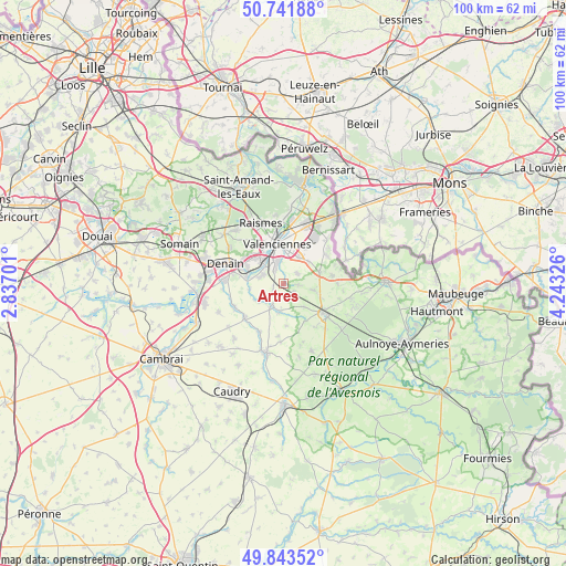
Artres GPS coordinates[2]
50° 17' 41.352" North, 3° 32' 24.468" East
| Map corner | latitude | longitude |
|---|---|---|
| Upper-left | 50.74188°, | 2.83701° |
| Center: | 50.29482°, | 3.54013° |
| Lower-right: | 49.84352°, | 4.24326° |
| Map W x H: | 99.9×99.9 km | = 62.1×62.1mi |
| max Lat: | 51.07786° ⇑4.5% North |
| Artres: | 50.29482° |
| min Lat: | ⇓95.5% South 41.3874° |
| min Long | Artres | max Long |
| -5.08615° | 3.54013° | 9.52242° |
| W 64.6%⇐ | ⇒35.4% E |
Elevation
Elevation of Artres is 60 m = 197 ft, and this is 133.7 m = 439 ft below average elevation for this country.
| Max E: |
2333 m = 7654 ft | 77.8% |
| Avg. | 193.7 m = 635 ft | |
| Artres | 60 m = 197 ft | |
Min E: |
-1 m = -3 ft | 22.2% |
See also: France elevation on elevation.city.
Geographical zone
Artres is located in North temperate zone (between Tropic of Cancer and the Arctic Circle). Distance of this North polar circle is 1808.9 km =1124 mi to North.| Distance of | km | miles | from Artres |
|---|---|---|---|
| North Pole | 4414.8 | 2743.2 | to North |
| Arctic Circle | 1808.9 | 1124 | to North |
| Tropic Cancer | 2986.3 | 1855.6 | to South |
| Equator | 5592.3 | 3474.9 | to South |


Nearby cities:
15 places around Artres: (largest is in red/bold)
• Aulnoy-lez-Valenciennes
4.3 km =2.7 mi,  353°
353°
• Bermerain
4.7 km =2.9 mi,  186°
186°
• Famars
2.9 km =1.8 mi,  329°
329°
• Maing
4.2 km =2.6 mi,  290°
290°
• Maresches
2.9 km =1.8 mi,  94°
94°
• Marly
5.7 km =3.5 mi,  6°
6°
• Préseau
3 km =1.9 mi,  53°
53°
• Quérénaing
2.1 km =1.3 mi,  243°
243°
• Ruesnes
5.1 km =3.2 mi,  142°
142°
• Saultain
5.4 km =3.4 mi,  29°
29°
• Sepmeries
2.2 km =1.4 mi,  129°
129°
• Trith-Saint-Léger
4.7 km =2.9 mi,  301°
301°
• Vendegies-sur-Écaillon
4.1 km =2.5 mi,  208°
208°
• Verchain-Maugré
5.4 km =3.4 mi, 236°
• Villers-Pol
5.4 km =3.4 mi,  102°
102°
Sources, notices
• [Note1] Compared only with cities in France existing in our database
• [Src1] Map data: © OpenStreetMap contributors (CC-BY-SA)
• [Src2] Other city data from geonames.org with taken over terms of usage.
• [Src3] Geographical zone / Annual Mean Temperature by Robert A. Rohde @ Wikipedia
