Préseau geodata
Préseau (Hauts-de-France) is a populated place; located in France in Europe/Paris (GMT+2) time zone. With population of 1,884 people, there are 5063 cities with bigger population in this country. Compared to other cities in France, 95.7% of cities are located further ↓South; 64.8% of cities are located further ←West and 71% of cities have higher elevation than Préseau. Note1
Administrative division(s):
- Level 1: Hauts-de-France
- Level 2: Nord
- Level 3: Arrondissement de Valenciennes
- Level 4: Préseau


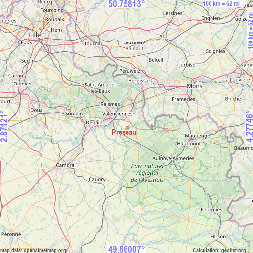
Préseau GPS coordinates[2]
50° 18' 40.392" North, 3° 34' 27.624" East
| Map corner | latitude | longitude |
|---|---|---|
| Upper-left | 50.75813°, | 2.87121° |
| Center: | 50.31122°, | 3.57434° |
| Lower-right: | 49.86007°, | 4.27746° |
| Map W x H: | 99.9×99.9 km | = 62.1×62.1mi |
| max Lat: | 51.07786° ⇑4.3% North |
| Préseau: | 50.31122° |
| min Lat: | ⇓95.7% South 41.3874° |
| min Long | Préseau | max Long |
| -5.08615° | 3.57434° | 9.52242° |
| W 64.8%⇐ | ⇒35.2% E |
Elevation
Elevation of Préseau is 76 m = 249 ft, and this is 117.7 m = 386 ft below average elevation for this country.
| Max E: |
2333 m = 7654 ft | 71% |
| Avg. | 193.7 m = 635 ft | |
| Préseau | 76 m = 249 ft | |
Min E: |
-1 m = -3 ft | 29% |
See also: France elevation on elevation.city.
Geographical zone
Préseau is located in North temperate zone (between Tropic of Cancer and the Arctic Circle). Distance of this North polar circle is 1807.1 km =1122.9 mi to North.| Distance of | km | miles | from Préseau |
|---|---|---|---|
| North Pole | 4413 | 2742.1 | to North |
| Arctic Circle | 1807.1 | 1122.9 | to North |
| Tropic Cancer | 2988.2 | 1856.8 | to South |
| Equator | 5594.1 | 3476 | to South |


Nearby cities:
15 places around Préseau: (largest is in red/bold)
• Artres
3 km =1.9 mi,  233°
233°
• Aulnoy-lez-Valenciennes
3.8 km =2.4 mi,  310°
310°
• Curgies
2.9 km =1.8 mi,  44°
44°
• Estreux
4.7 km =2.9 mi,  17°
17°
• Famars
4 km =2.5 mi,  280°
280°
• Jenlain
3.9 km =2.4 mi,  89°
89°
• Maresches
2.1 km =1.3 mi,  167°
167°
• Marly
4.2 km =2.6 mi,  335°
335°
• Quérénaing
5.1 km =3.2 mi,  237°
237°
• Ruesnes
5.9 km =3.7 mi, 173°
• Saultain
2.8 km =1.7 mi,  4°
4°
• Sebourg
6 km =3.7 mi,  54°
54°
• Sepmeries
3.3 km =2.1 mi,  193°
193°
• Villers-Pol
4.1 km =2.5 mi,  136°
136°
• Wargnies-le-Grand
6.1 km =3.8 mi, 93°
Sources, notices
• [Note1] Compared only with cities in France existing in our database
• [Src1] Map data: © OpenStreetMap contributors (CC-BY-SA)
• [Src2] Other city data from geonames.org with taken over terms of usage.
• [Src3] Geographical zone / Annual Mean Temperature by Robert A. Rohde @ Wikipedia
