Seclin geodata
Seclin (Hauts-de-France) is a populated place; located in France in Europe/Paris (GMT+2) time zone. With population of 12,214 people, there are 786 cities with bigger population in this country. Compared to other cities in France, 97.7% of cities are located further ↓South; 58.2% of cities are located further ←West and 91.2% of cities have higher elevation than Seclin. Note1
Administrative division(s):
- Level 1: Hauts-de-France
- Level 2: Nord
- Level 3: Arrondissement de Lille
- Level 4: Seclin


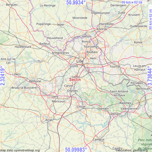
Seclin GPS coordinates[2]
50° 32' 55.428" North, 3° 1' 38.316" East
| Map corner | latitude | longitude |
|---|---|---|
| Upper-left | 50.9934°, | 2.32419° |
| Center: | 50.54873°, | 3.02731° |
| Lower-right: | 50.09983°, | 3.73044° |
| Map W x H: | 99.4×99.4 km | = 61.8×61.8mi |
| max Lat: | 51.07786° ⇑2.3% North |
| Seclin: | 50.54873° |
| min Lat: | ⇓97.7% South 41.3874° |
| min Long | Seclin | max Long |
| -5.08615° | 3.02731° | 9.52242° |
| W 58.2%⇐ | ⇒41.8% E |
Elevation
Elevation of Seclin is 27 m = 89 ft, and this is 166.7 m = 547 ft below average elevation for this country.
| Max E: |
2333 m = 7654 ft | 91.2% |
| Avg. | 193.7 m = 635 ft | |
| Seclin | 27 m = 89 ft | |
Min E: |
-1 m = -3 ft | 8.8% |
See also: France elevation on elevation.city.
Geographical zone
Seclin is located in North temperate zone (between Tropic of Cancer and the Arctic Circle). Distance of this North polar circle is 1780.7 km =1106.5 mi to North.| Distance of | km | miles | from Seclin |
|---|---|---|---|
| North Pole | 4386.6 | 2725.7 | to North |
| Arctic Circle | 1780.7 | 1106.5 | to North |
| Tropic Cancer | 3014.6 | 1873.2 | to South |
| Equator | 5620.5 | 3492.4 | to South |


Nearby cities:
15 places around Seclin: (largest is in red/bold)
• Allennes-les-Marais
5.4 km =3.4 mi,  256°
256°
• Attiches
3.8 km =2.4 mi,  140°
140°
• Avelin
4 km =2.5 mi,  104°
104°
• Camphin-en-Carembault
5 km =3.1 mi,  214°
214°
• Carnin
5.7 km =3.5 mi,  234°
234°
• Chemy
3.4 km =2.1 mi, 234°
• Emmerin
5.4 km =3.4 mi,  340°
340°
• Faches-Thumesnil
4.7 km =2.9 mi,  35°
35°
• Gondecourt
3.1 km =1.9 mi, 261°
• Houplin-Ancoisne
2.4 km =1.5 mi,  311°
311°
• Noyelles-lès-Seclin
3.2 km =2 mi,  346°
346°
• Phalempin
3.6 km =2.2 mi,  192°
192°
• Templemars
3.4 km =2.1 mi,  34°
34°
• Vendeville
4.8 km =3 mi,  49°
49°
• Wattignies
4.3 km =2.7 mi,  15°
15°
Sources, notices
• [Note1] Compared only with cities in France existing in our database
• [Src1] Map data: © OpenStreetMap contributors (CC-BY-SA)
• [Src2] Other city data from geonames.org with taken over terms of usage.
• [Src3] Geographical zone / Annual Mean Temperature by Robert A. Rohde @ Wikipedia
