Noyelles-lès-Seclin geodata
Noyelles-lès-Seclin (Hauts-de-France) is a populated place; located in France in Europe/Paris (GMT+2) time zone. With population of 869 people, there are 9902 cities with bigger population in this country. Compared to other cities in France, 97.9% of cities are located further ↓South; 58.1% of cities are located further ←West and 92.7% of cities have higher elevation than Noyelles-lès-Seclin. Note1
Administrative division(s):
- Level 1: Hauts-de-France
- Level 2: Nord
- Level 3: Arrondissement de Lille
- Level 4: Noyelles-lès-Seclin


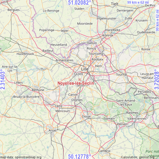
Noyelles-lès-Seclin GPS coordinates[2]
50° 34' 35.112" North, 3° 1' 1.74" East
| Map corner | latitude | longitude |
|---|---|---|
| Upper-left | 51.02082°, | 2.31403° |
| Center: | 50.57642°, | 3.01715° |
| Lower-right: | 50.12778°, | 3.72028° |
| Map W x H: | 99.3×99.3 km | = 61.7×61.7mi |
| max Lat: | 51.07786° ⇑2.1% North |
| Noyelles-lès-Seclin: | 50.57642° |
| min Lat: | ⇓97.9% South 41.3874° |
| min Long | Noyelles-lès-S | max Long |
| -5.08615° | 3.01715° | 9.52242° |
| W 58.1%⇐ | ⇒41.9% E |
Elevation
Elevation of Noyelles-lès-Seclin is 23 m = 75 ft, and this is 170.7 m = 560 ft below average elevation for this country.
| Max E: |
2333 m = 7654 ft | 92.7% |
| Avg. | 193.7 m = 635 ft | |
| Noyelles-lès-Seclin | 23 m = 75 ft | |
Min E: |
-1 m = -3 ft | 7.3% |
See also: France elevation on elevation.city.
Geographical zone
Noyelles-lès-Seclin is located in North temperate zone (between Tropic of Cancer and the Arctic Circle). Distance of this North polar circle is 1777.6 km =1104.5 mi to North.| Distance of | km | miles | from Noyelles-lès-Seclin |
|---|---|---|---|
| North Pole | 4383.5 | 2723.8 | to North |
| Arctic Circle | 1777.6 | 1104.5 | to North |
| Tropic Cancer | 3017.7 | 1875.1 | to South |
| Equator | 5623.6 | 3494.3 | to South |


Nearby cities:
15 places around Noyelles-lès-Seclin: (largest is in red/bold)
• Chemy
5.4 km =3.4 mi,  201°
201°
• Emmerin
2.3 km =1.4 mi,  331°
331°
• Faches-Thumesnil
3.6 km =2.2 mi,  77°
77°
• Gondecourt
4.2 km =2.6 mi,  213°
213°
• Hallennes-lez-Haubourdin
5.7 km =3.5 mi,  321°
321°
• Haubourdin
4 km =2.5 mi, 332°
• Houplin-Ancoisne
1.8 km =1.1 mi, 214°
• Loos
3.7 km =2.3 mi,  1°
1°
• Ronchin
5.8 km =3.6 mi,  64°
64°
• Santes
4.3 km =2.7 mi,  295°
295°
• Seclin
3.2 km =2 mi,  166°
166°
• Templemars
2.6 km =1.6 mi,  96°
96°
• Vendeville
4.3 km =2.7 mi,  89°
89°
• Wattignies
2.2 km =1.4 mi, 59°
• Wavrin
5.7 km =3.5 mi,  267°
267°
Sources, notices
• [Note1] Compared only with cities in France existing in our database
• [Src1] Map data: © OpenStreetMap contributors (CC-BY-SA)
• [Src2] Other city data from geonames.org with taken over terms of usage.
• [Src3] Geographical zone / Annual Mean Temperature by Robert A. Rohde @ Wikipedia
