Carnin geodata
Carnin (Hauts-de-France) is a populated place; located in France in Europe/Paris (GMT+2) time zone. With population of 993 people, there are 8879 cities with bigger population in this country. Compared to other cities in France, 97.5% of cities are located further ↓South; 57.3% of cities are located further ←West and 90.3% of cities have higher elevation than Carnin. Note1
Administrative division(s):
- Level 1: Hauts-de-France
- Level 2: Nord
- Level 3: Arrondissement de Lille
- Level 4: Carnin


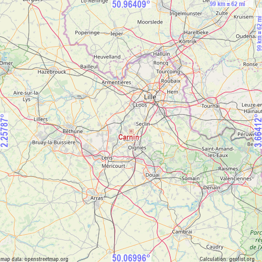
Carnin GPS coordinates[2]
50° 31' 8.904" North, 2° 57' 39.564" East
| Map corner | latitude | longitude |
|---|---|---|
| Upper-left | 50.96409°, | 2.25787° |
| Center: | 50.51914°, | 2.96099° |
| Lower-right: | 50.06996°, | 3.66412° |
| Map W x H: | 99.4×99.4 km | = 61.8×61.8mi |
| max Lat: | 51.07786° ⇑2.5% North |
| Carnin: | 50.51914° |
| min Lat: | ⇓97.5% South 41.3874° |
| min Long | Carnin | max Long |
| -5.08615° | 2.96099° | 9.52242° |
| W 57.3%⇐ | ⇒42.7% E |
Elevation
Elevation of Carnin is 29 m = 95 ft, and this is 164.7 m = 540 ft below average elevation for this country.
| Max E: |
2333 m = 7654 ft | 90.3% |
| Avg. | 193.7 m = 635 ft | |
| Carnin | 29 m = 95 ft | |
Min E: |
-1 m = -3 ft | 9.7% |
See also: France elevation on elevation.city.
Geographical zone
Carnin is located in North temperate zone (between Tropic of Cancer and the Arctic Circle). Distance of this North polar circle is 1784 km =1108.5 mi to North.| Distance of | km | miles | from Carnin |
|---|---|---|---|
| North Pole | 4389.9 | 2727.8 | to North |
| Arctic Circle | 1784 | 1108.5 | to North |
| Tropic Cancer | 3011.3 | 1871.1 | to South |
| Equator | 5617.2 | 3490.4 | to South |


Nearby cities:
15 places around Carnin: (largest is in red/bold)
• Allennes-les-Marais
2.1 km =1.3 mi,  345°
345°
• Annoeullin
2.3 km =1.4 mi,  298°
298°
• Bauvin
4.7 km =2.9 mi,  267°
267°
• Camphin-en-Carembault
2 km =1.2 mi,  113°
113°
• Carvin
3 km =1.9 mi,  183°
183°
• Chemy
2.4 km =1.5 mi,  55°
55°
• Don
4.5 km =2.8 mi,  317°
317°
• Gondecourt
3.3 km =2.1 mi,  29°
29°
• Houplin-Ancoisne
5.7 km =3.5 mi, 31°
• Libercourt
5.6 km =3.5 mi,  135°
135°
• Meurchin
5.3 km =3.3 mi,  244°
244°
• Phalempin
3.9 km =2.4 mi,  93°
93°
• Provin
3.8 km =2.4 mi,  261°
261°
• Seclin
5.7 km =3.5 mi,  54°
54°
• Épinoy
4.1 km =2.5 mi,  196°
196°
Sources, notices
• [Note1] Compared only with cities in France existing in our database
• [Src1] Map data: © OpenStreetMap contributors (CC-BY-SA)
• [Src2] Other city data from geonames.org with taken over terms of usage.
• [Src3] Geographical zone / Annual Mean Temperature by Robert A. Rohde @ Wikipedia
