Schnersheim geodata
Schnersheim (Grand Est) is a populated place; located in France in Europe/Paris (GMT+2) time zone. With population of 1,055 people, there are 8433 cities with bigger population in this country. Compared to other cities in France, 72.2% of cities are located further ↓South; 98.4% of cities are located further ←West and 66.6% of cities have lower elevation than Schnersheim. Note1
Administrative division(s):
- Level 1: Grand Est
- Level 2: Bas-Rhin
- Level 3: Arrondissement de Saverne
- Level 4: Schnersheim


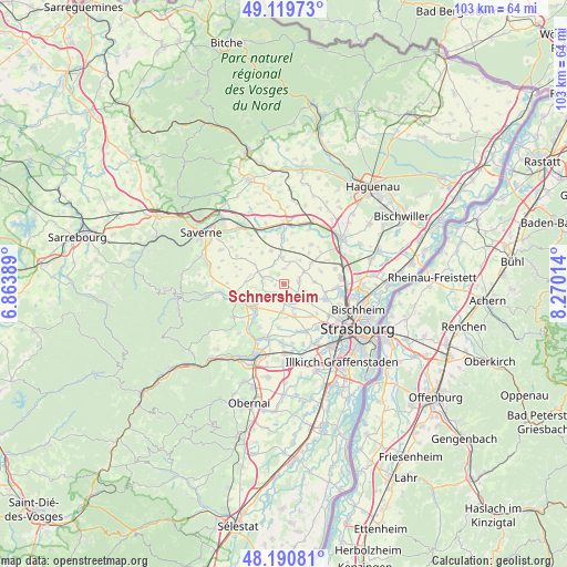
Schnersheim GPS coordinates[2]
48° 39' 26.676" North, 7° 34' 1.236" East
| Map corner | latitude | longitude |
|---|---|---|
| Upper-left | 49.11973°, | 6.86389° |
| Center: | 48.65741°, | 7.56701° |
| Lower-right: | 48.19081°, | 8.27014° |
| Map W x H: | 103.3×103.3 km | = 64.2×64.2mi |
| max Lat: | 51.07786° ⇑27.8% North |
| Schnersheim: | 48.65741° |
| min Lat: | ⇓72.2% South 41.3874° |
| min Long | Schnersheim | max Long |
| -5.08615° | 7.56701° | 9.52242° |
| W 98.4%⇐ | ⇒1.6% E |
Elevation
Elevation of Schnersheim is 202 m = 663 ft, and this is 8.3 m = 27 ft above average elevation for this country.
| Max E: |
2333 m = 7654 ft | 33.4% |
| Schnersheim | 202 m 663 ft | |
| Avg. | 193.7 m = 635 ft | |
Min E: |
-1 m = -3 ft | 66.6% |
See also: France elevation on elevation.city.
Geographical zone
Schnersheim is located in North temperate zone (between Tropic of Cancer and the Arctic Circle). Distance of this North polar circle is 1991 km =1237.1 mi to North.| Distance of | km | miles | from Schnersheim |
|---|---|---|---|
| North Pole | 4596.9 | 2856.4 | to North |
| Arctic Circle | 1991 | 1237.1 | to North |
| Tropic Cancer | 2804.3 | 1742.5 | to South |
| Equator | 5410.2 | 3361.7 | to South |


Nearby cities:
15 places around Schnersheim: (largest is in red/bold)
• Duntzenheim
6.5 km =4 mi,  339°
339°
• Durningen
2.9 km =1.8 mi,  2°
2°
• Furdenheim
5.1 km =3.2 mi,  184°
184°
• Ittenheim
6.1 km =3.8 mi,  161°
161°
• Ittlenheim
1.6 km =1 mi,  258°
258°
• Kienheim
3.7 km =2.3 mi,  15°
15°
• Kuttolsheim
3.4 km =2.1 mi,  243°
243°
• Marlenheim
6.9 km =4.3 mi,  234°
234°
• Nordheim
5 km =3.1 mi, 240°
• Offenheim
4.6 km =2.9 mi,  127°
127°
• Pfettisheim
5.8 km =3.6 mi,  87°
87°
• Quatzenheim
3.4 km =2.1 mi,  171°
171°
• Truchtersheim
3 km =1.9 mi,  77°
77°
• Willgottheim
4.3 km =2.7 mi,  289°
289°
• Wiwersheim
3.5 km =2.2 mi,  123°
123°
Sources, notices
• [Note1] Compared only with cities in France existing in our database
• [Src1] Map data: © OpenStreetMap contributors (CC-BY-SA)
• [Src2] Other city data from geonames.org with taken over terms of usage.
• [Src3] Geographical zone / Annual Mean Temperature by Robert A. Rohde @ Wikipedia
