Ittenheim geodata
Ittenheim (Grand Est) is a populated place; located in France in Europe/Paris (GMT+2) time zone. With population of 2,100 people, there are 4591 cities with bigger population in this country. Compared to other cities in France, 71% of cities are located further ↓South; 98.5% of cities are located further ←West and 61.5% of cities have lower elevation than Ittenheim. Note1
Administrative division(s):
- Level 1: Grand Est
- Level 2: Bas-Rhin
- Level 3: Arrondissement de Saverne
- Level 4: Ittenheim


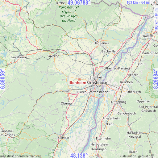
Ittenheim GPS coordinates[2]
48° 36' 18.288" North, 7° 35' 37.392" East
| Map corner | latitude | longitude |
|---|---|---|
| Upper-left | 49.06788°, | 6.89059° |
| Center: | 48.60508°, | 7.59372° |
| Lower-right: | 48.138°, | 8.29684° |
| Map W x H: | 103.4×103.4 km | = 64.2×64.2mi |
| max Lat: | 51.07786° ⇑29% North |
| Ittenheim: | 48.60508° |
| min Lat: | ⇓71% South 41.3874° |
| min Long | Ittenheim | max Long |
| -5.08615° | 7.59372° | 9.52242° |
| W 98.5%⇐ | ⇒1.5% E |
Elevation
Elevation of Ittenheim is 177 m = 581 ft, and this is 16.7 m = 55 ft below average elevation for this country.
| Max E: |
2333 m = 7654 ft | 38.5% |
| Avg. | 193.7 m = 635 ft | |
| Ittenheim | 177 m = 581 ft | |
Min E: |
-1 m = -3 ft | 61.5% |
See also: France elevation on elevation.city.
Geographical zone
Ittenheim is located in North temperate zone (between Tropic of Cancer and the Arctic Circle). Distance of this North polar circle is 1996.8 km =1240.8 mi to North.| Distance of | km | miles | from Ittenheim |
|---|---|---|---|
| North Pole | 4602.7 | 2860 | to North |
| Arctic Circle | 1996.8 | 1240.8 | to North |
| Tropic Cancer | 2798.5 | 1738.9 | to South |
| Equator | 5404.4 | 3358.1 | to South |


Nearby cities:
15 places around Ittenheim: (largest is in red/bold)
• Achenheim
3.7 km =2.3 mi,  137°
137°
• Breuschwickersheim
2.8 km =1.7 mi,  168°
168°
• Dingsheim
6.2 km =3.9 mi,  63°
63°
• Ergersheim
6.2 km =3.9 mi,  231°
231°
• Ernolsheim-Bruche
4.9 km =3 mi,  205°
205°
• Furdenheim
2.5 km =1.6 mi,  286°
286°
• Hangenbieten
5.3 km =3.3 mi,  162°
162°
• Kolbsheim
4.9 km =3 mi,  183°
183°
• Oberschaeffolsheim
4.6 km =2.9 mi,  116°
116°
• Offenheim
3.4 km =2.1 mi,  29°
29°
• Osthoffen
3.4 km =2.1 mi, 233°
• Quatzenheim
2.9 km =1.8 mi,  329°
329°
• Schnersheim
6.1 km =3.8 mi,  341°
341°
• Wiwersheim
4 km =2.5 mi,  13°
13°
• Wolfisheim
5.7 km =3.5 mi,  110°
110°
Sources, notices
• [Note1] Compared only with cities in France existing in our database
• [Src1] Map data: © OpenStreetMap contributors (CC-BY-SA)
• [Src2] Other city data from geonames.org with taken over terms of usage.
• [Src3] Geographical zone / Annual Mean Temperature by Robert A. Rohde @ Wikipedia
