Sauvagnon geodata
Sauvagnon (Nouvelle-Aquitaine) is a populated place; located in France in Europe/Paris (GMT+2) time zone. With population of 2,531 people, there are 3851 cities with bigger population in this country. Compared to other cities in France, 94.2% of cities are located further ↑North; 81.9% of cities are located further →East and 64.9% of cities have lower elevation than Sauvagnon. Note1
Administrative division(s):
- Level 1: Nouvelle-Aquitaine
- Level 2: Département des Pyrénées-Atlantiques
- Level 3: Arrondissement de Pau
- Level 4: Sauvagnon


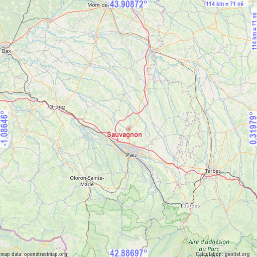
Sauvagnon GPS coordinates[2]
43° 24' 0" North, 0° 22' 59.988" West
| Map corner | latitude | longitude |
|---|---|---|
| Upper-left | 43.90872°, | -1.08646° |
| Center: | 43.4°, | -0.38333° |
| Lower-right: | 42.88697°, | 0.31979° |
| Map W x H: | 113.6×113.6 km | = 70.6×70.6mi |
| max Lat: | 51.07786° ⇑94.2% North |
| Sauvagnon: | 43.4° |
| min Lat: | ⇓5.8% South 41.3874° |
| min Long | Sauvagnon | max Long |
| -5.08615° | -0.38333° | 9.52242° |
| W 18.1%⇐ | ⇒81.9% E |
Elevation
Elevation of Sauvagnon is 193 m = 633 ft, and this is 0.69999999999999 m = 2 ft below average elevation for this country.
| Max E: |
2333 m = 7654 ft | 35.1% |
| Avg. | 193.7 m = 635 ft | |
| Sauvagnon | 193 m = 633 ft | |
Min E: |
-1 m = -3 ft | 64.9% |
See also: France elevation on elevation.city.
Geographical zone
Sauvagnon is located in North temperate zone (between Tropic of Cancer and the Arctic Circle). Distance of this Northern Tropic circle is 2219.7 km =1379.3 mi to South.| Distance of | km | miles | from Sauvagnon |
|---|---|---|---|
| North Pole | 5181.4 | 3219.6 | to North |
| Arctic Circle | 2575.5 | 1600.3 | to North |
| Tropic Cancer | 2219.7 | 1379.3 | to South |
| Equator | 4825.6 | 2998.5 | to South |


Nearby cities:
15 places around Sauvagnon: (largest is in red/bold)
• Barinque
9.4 km =5.8 mi,  90°
90°
• Bernadets
8.3 km =5.2 mi,  102°
102°
• Bougarber
6.7 km =4.2 mi,  270°
270°
• Buros
8.7 km =5.4 mi,  129°
129°
• Lescar
7.9 km =4.9 mi,  199°
199°
• Lons
9.4 km =5.8 mi,  188°
188°
• Mazerolles
8.7 km =5.4 mi,  309°
309°
• Montardon
4.6 km =2.9 mi,  143°
143°
• Navailles-Angos
4.4 km =2.7 mi,  65°
65°
• Poey-de-Lescar
8.7 km =5.4 mi,  230°
230°
• Saint-Armou
7 km =4.3 mi, 74°
• Saint-Castin
7 km =4.3 mi,  105°
105°
• Serres-Castet
3.3 km =2.1 mi,  124°
124°
• Thèze
9.6 km =6 mi,  16°
16°
• Uzein
4 km =2.5 mi, 270°
Sources, notices
• [Note1] Compared only with cities in France existing in our database
• [Src1] Map data: © OpenStreetMap contributors (CC-BY-SA)
• [Src2] Other city data from geonames.org with taken over terms of usage.
• [Src3] Geographical zone / Annual Mean Temperature by Robert A. Rohde @ Wikipedia
