Thèze geodata
Thèze (Nouvelle-Aquitaine) is a populated place; located in France in Europe/Paris (GMT+2) time zone. With population of 750 people, there are 11167 cities with bigger population in this country. Compared to other cities in France, 93.3% of cities are located further ↑North; 81.4% of cities are located further →East and 70.6% of cities have lower elevation than Thèze. Note1
Administrative division(s):
- Level 1: Nouvelle-Aquitaine
- Level 2: Département des Pyrénées-Atlantiques
- Level 3: Arrondissement de Pau
- Level 4: Thèze


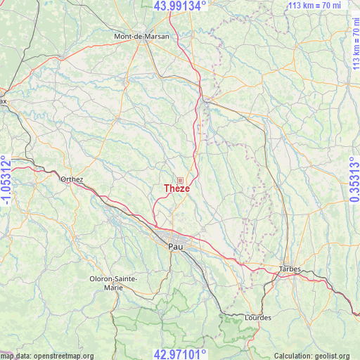
Thèze GPS coordinates[2]
43° 28' 59.988" North, 0° 21' 0" West
| Map corner | latitude | longitude |
|---|---|---|
| Upper-left | 43.99134°, | -1.05312° |
| Center: | 43.48333°, | -0.35° |
| Lower-right: | 42.97101°, | 0.35313° |
| Map W x H: | 113.5×113.4 km | = 70.5×70.5mi |
| max Lat: | 51.07786° ⇑93.3% North |
| Thèze: | 43.48333° |
| min Lat: | ⇓6.7% South 41.3874° |
| min Long | Thèze | max Long |
| -5.08615° | -0.35° | 9.52242° |
| W 18.6%⇐ | ⇒81.4% E |
Elevation
Elevation of Thèze is 222 m = 728 ft, and this is 28.3 m = 93 ft above average elevation for this country.
| Max E: |
2333 m = 7654 ft | 29.4% |
| Thèze | 222 m 728 ft | |
| Avg. | 193.7 m = 635 ft | |
Min E: |
-1 m = -3 ft | 70.6% |
See also: France elevation on elevation.city.
Geographical zone
Thèze is located in North temperate zone (between Tropic of Cancer and the Arctic Circle). Distance of this Northern Tropic circle is 2229 km =1385 mi to South.| Distance of | km | miles | from Thèze |
|---|---|---|---|
| North Pole | 5172.2 | 3213.9 | to North |
| Arctic Circle | 2566.3 | 1594.6 | to North |
| Tropic Cancer | 2229 | 1385 | to South |
| Equator | 4834.9 | 3004.3 | to South |


Nearby cities:
15 places around Thèze: (largest is in red/bold)
• Arzacq-Arraziguet
7.7 km =4.8 mi,  315°
315°
• Barinque
11.5 km =7.1 mi,  144°
144°
• Bernadets
12.4 km =7.7 mi,  154°
154°
• Bougarber
13.2 km =8.2 mi,  225°
225°
• Garlin
10.5 km =6.5 mi,  36°
36°
• Mazerolles
10.1 km =6.3 mi,  248°
248°
• Montardon
13 km =8.1 mi,  180°
180°
• Navailles-Angos
7.5 km =4.7 mi,  169°
169°
• Saint-Armou
8.4 km =5.2 mi, 151°
• Saint-Castin
11.8 km =7.3 mi,  160°
160°
• Sainte-Marie-de-Gosse
12 km =7.5 mi,  51°
51°
• Sauvagnon
9.6 km =6 mi,  196°
196°
• Serres-Castet
11.1 km =6.9 mi, 180°
• Sévignacq
7.7 km =4.8 mi,  118°
118°
• Uzein
11.5 km =7.1 mi,  215°
215°
Sources, notices
• [Note1] Compared only with cities in France existing in our database
• [Src1] Map data: © OpenStreetMap contributors (CC-BY-SA)
• [Src2] Other city data from geonames.org with taken over terms of usage.
• [Src3] Geographical zone / Annual Mean Temperature by Robert A. Rohde @ Wikipedia
