Mazerolles geodata
Mazerolles (Nouvelle-Aquitaine) is a populated place; located in France in Europe/Paris (GMT+2) time zone. With population of 812 people, there are 10458 cities with bigger population in this country. Compared to other cities in France, 93.7% of cities are located further ↑North; 83% of cities are located further →East and 50.9% of cities have higher elevation than Mazerolles. Note1
Administrative division(s):
- Level 1: Nouvelle-Aquitaine
- Level 2: Département des Pyrénées-Atlantiques
- Level 3: Arrondissement de Pau
- Level 4: Mazerolles


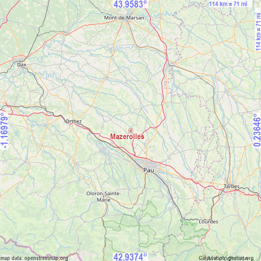
Mazerolles GPS coordinates[2]
43° 27' 0" North, 0° 28' 0.012" West
| Map corner | latitude | longitude |
|---|---|---|
| Upper-left | 43.9583°, | -1.16979° |
| Center: | 43.45°, | -0.46667° |
| Lower-right: | 42.9374°, | 0.23646° |
| Map W x H: | 113.5×113.5 km | = 70.5×70.5mi |
| max Lat: | 51.07786° ⇑93.7% North |
| Mazerolles: | 43.45° |
| min Lat: | ⇓6.3% South 41.3874° |
| min Long | Mazerolles | max Long |
| -5.08615° | -0.46667° | 9.52242° |
| W 17%⇐ | ⇒83% E |
Elevation
Elevation of Mazerolles is 129 m = 423 ft, and this is 64.7 m = 212 ft below average elevation for this country.
| Max E: |
2333 m = 7654 ft | 50.9% |
| Avg. | 193.7 m = 635 ft | |
| Mazerolles | 129 m = 423 ft | |
Min E: |
-1 m = -3 ft | 49.1% |
See also: France elevation on elevation.city.
Geographical zone
Mazerolles is located in North temperate zone (between Tropic of Cancer and the Arctic Circle). Distance of this Northern Tropic circle is 2225.3 km =1382.7 mi to South.| Distance of | km | miles | from Mazerolles |
|---|---|---|---|
| North Pole | 5175.9 | 3216.2 | to North |
| Arctic Circle | 2570 | 1596.9 | to North |
| Tropic Cancer | 2225.3 | 1382.7 | to South |
| Equator | 4831.2 | 3002 | to South |


Nearby cities:
15 places around Mazerolles: (largest is in red/bold)
• Arthez-de-Béarn
10.9 km =6.8 mi,  279°
279°
• Artix
10.4 km =6.5 mi,  235°
235°
• Arzacq-Arraziguet
10.1 km =6.3 mi,  23°
23°
• Aussevielle
11.2 km =7 mi,  186°
186°
• Bougarber
5.6 km =3.5 mi,  180°
180°
• Denguin
9.6 km =6 mi,  196°
196°
• Montardon
13.2 km =8.2 mi,  134°
134°
• Mourenx
13.1 km =8.1 mi, 235°
• Navailles-Angos
11.4 km =7.1 mi,  108°
108°
• Poey-de-Lescar
11.1 km =6.9 mi, 180°
• Sauvagnon
8.7 km =5.4 mi, 129°
• Serres-Castet
12 km =7.5 mi, 128°
• Siros
11.9 km =7.4 mi, 185°
• Thèze
10.1 km =6.3 mi,  68°
68°
• Uzein
6.2 km =3.9 mi,  154°
154°
Sources, notices
• [Note1] Compared only with cities in France existing in our database
• [Src1] Map data: © OpenStreetMap contributors (CC-BY-SA)
• [Src2] Other city data from geonames.org with taken over terms of usage.
• [Src3] Geographical zone / Annual Mean Temperature by Robert A. Rohde @ Wikipedia
