Sallanches geodata
Sallanches (Auvergne-Rhône-Alpes) is a populated place; located in France in Europe/Paris (GMT+2) time zone. With population of 16,725 people, there are 568 cities with bigger population in this country. Compared to other cities in France, 67% of cities are located further ↑North; 92.5% of cities are located further ←West and 94% of cities have lower elevation than Sallanches. Note1
Administrative division(s):
- Level 1: Auvergne-Rhône-Alpes
- Level 2: Haute-Savoie
- Level 3: Arrondissement de Bonneville
- Level 4: Sallanches


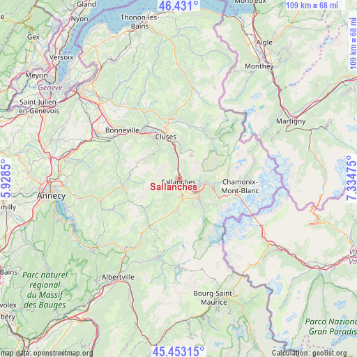
Sallanches GPS coordinates[2]
45° 56' 39.228" North, 6° 37' 53.832" East
| Map corner | latitude | longitude |
|---|---|---|
| Upper-left | 46.431°, | 5.9285° |
| Center: | 45.94423°, | 6.63162° |
| Lower-right: | 45.45315°, | 7.33475° |
| Map W x H: | 108.7×108.7 km | = 67.5×67.5mi |
| max Lat: | 51.07786° ⇑67% North |
| Sallanches: | 45.94423° |
| min Lat: | ⇓33% South 41.3874° |
| min Long | Sallanches | max Long |
| -5.08615° | 6.63162° | 9.52242° |
| W 92.5%⇐ | ⇒7.5% E |
Elevation
Elevation of Sallanches is 542 m = 1778 ft, and this is 348.3 m = 1143 ft above average elevation for this country.
| Max E: |
2333 m = 7654 ft | 6% |
| Sallanches | 542 m 1778 ft | |
| Avg. | 193.7 m = 635 ft | |
Min E: |
-1 m = -3 ft | 94% |
See also: France elevation on elevation.city.
Geographical zone
Sallanches is located in North temperate zone (between Tropic of Cancer and the Arctic Circle). Distance of this North polar circle is 2292.7 km =1424.6 mi to North.| Distance of | km | miles | from Sallanches |
|---|---|---|---|
| North Pole | 4898.5 | 3043.8 | to North |
| Arctic Circle | 2292.7 | 1424.6 | to North |
| Tropic Cancer | 2502.6 | 1555 | to South |
| Equator | 5108.5 | 3174.3 | to South |


Nearby cities:
15 places around Sallanches: (largest is in red/bold)
• Arâches-la-Frasse
11 km =6.8 mi,  359°
359°
• Cluses
13.9 km =8.6 mi,  341°
341°
• Combloux
5.2 km =3.2 mi,  169°
169°
• Cordon
3.3 km =2.1 mi,  218°
218°
• Domancy
3.9 km =2.4 mi,  155°
155°
• La Giettaz
13.9 km =8.6 mi,  229°
229°
• Les Houches
14.7 km =9.1 mi,  112°
112°
• Magland
8.5 km =5.3 mi,  354°
354°
• Megève
9.8 km =6.1 mi,  186°
186°
• Passy
5.5 km =3.4 mi,  115°
115°
• Praz-sur-Arly
12.7 km =7.9 mi,  201°
201°
• Saint-Gervais-les-Bains
8.8 km =5.5 mi,  131°
131°
• Saint-Sigismond
14.6 km =9.1 mi, 354°
• Scionzier
14.3 km =8.9 mi,  334°
334°
• Servoz
10.2 km =6.3 mi,  97°
97°
Sources, notices
• [Note1] Compared only with cities in France existing in our database
• [Src1] Map data: © OpenStreetMap contributors (CC-BY-SA)
• [Src2] Other city data from geonames.org with taken over terms of usage.
• [Src3] Geographical zone / Annual Mean Temperature by Robert A. Rohde @ Wikipedia
