Praz-sur-Arly geodata
Praz-sur-Arly (Auvergne-Rhône-Alpes) is a populated place; located in France in Europe/Paris (GMT+2) time zone. With population of 1,197 people, there are 7552 cities with bigger population in this country. Compared to other cities in France, 68.7% of cities are located further ↑North; 92.2% of cities are located further ←West and 99.1% of cities have lower elevation than Praz-sur-Arly. Note1
Administrative division(s):
- Level 1: Auvergne-Rhône-Alpes
- Level 2: Haute-Savoie
- Level 3: Arrondissement de Bonneville
- Level 4: Praz-sur-Arly


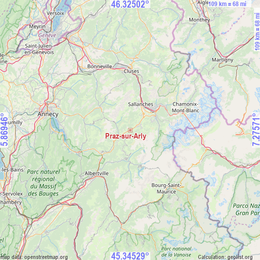
Praz-sur-Arly GPS coordinates[2]
45° 50' 14.316" North, 6° 34' 21.324" East
| Map corner | latitude | longitude |
|---|---|---|
| Upper-left | 46.32502°, | 5.86946° |
| Center: | 45.83731°, | 6.57259° |
| Lower-right: | 45.34529°, | 7.27571° |
| Map W x H: | 108.9×108.9 km | = 67.7×67.7mi |
| max Lat: | 51.07786° ⇑68.7% North |
| Praz-sur-Arly: | 45.83731° |
| min Lat: | ⇓31.3% South 41.3874° |
| min Long | Praz-sur-Arly | max Long |
| -5.08615° | 6.57259° | 9.52242° |
| W 92.2%⇐ | ⇒7.8% E |
Elevation
Elevation of Praz-sur-Arly is 1012 m = 3320 ft, and this is 818.3 m = 2685 ft above average elevation for this country.
| Max E: |
2333 m = 7654 ft | 0.90000000000001% |
| Praz-sur-Arly | 1012 m 3320 ft | |
| Avg. | 193.7 m = 635 ft | |
Min E: |
-1 m = -3 ft | 99.1% |
See also: France elevation on elevation.city.
Geographical zone
Praz-sur-Arly is located in North temperate zone (between Tropic of Cancer and the Arctic Circle). Distance of this North polar circle is 2304.5 km =1431.9 mi to North.| Distance of | km | miles | from Praz-sur-Arly |
|---|---|---|---|
| North Pole | 4910.4 | 3051.2 | to North |
| Arctic Circle | 2304.5 | 1431.9 | to North |
| Tropic Cancer | 2490.7 | 1547.6 | to South |
| Equator | 5096.6 | 3166.9 | to South |


Nearby cities:
15 places around Praz-sur-Arly: (largest is in red/bold)
• Beaufort
13.1 km =8.1 mi,  179°
179°
• Combloux
8.7 km =5.4 mi,  39°
39°
• Cordon
9.6 km =6 mi,  15°
15°
• Domancy
10.4 km =6.5 mi, 36°
• Flumet
5 km =3.1 mi,  244°
244°
• Hauteluce
9.8 km =6.1 mi, 176°
• La Clusaz
13.2 km =8.2 mi,  305°
305°
• La Giettaz
6.7 km =4.2 mi,  295°
295°
• Les Contamines-Montjoie
12.2 km =7.6 mi,  98°
98°
• Megève
4.1 km =2.5 mi,  58°
58°
• Notre-Dame-de-Bellecombe
5.3 km =3.3 mi,  232°
232°
• Passy
13.5 km =8.4 mi, 44°
• Saint-Gervais-les-Bains
12.7 km =7.9 mi, 61°
• Sallanches
12.7 km =7.9 mi, 21°
• Villard-sur-Doron
12.6 km =7.8 mi,  191°
191°
Sources, notices
• [Note1] Compared only with cities in France existing in our database
• [Src1] Map data: © OpenStreetMap contributors (CC-BY-SA)
• [Src2] Other city data from geonames.org with taken over terms of usage.
• [Src3] Geographical zone / Annual Mean Temperature by Robert A. Rohde @ Wikipedia
