Les Houches geodata
Les Houches (Auvergne-Rhône-Alpes) is a populated place; located in France in Europe/Paris (GMT+2) time zone. With population of 2,985 people, there are 3271 cities with bigger population in this country. Compared to other cities in France, 67.8% of cities are located further ↑North; 93.7% of cities are located further ←West and 99.1% of cities have lower elevation than Les Houches. Note1
Administrative division(s):
- Level 1: Auvergne-Rhône-Alpes
- Level 2: Haute-Savoie
- Level 3: Arrondissement de Bonneville
- Level 4: Les Houches


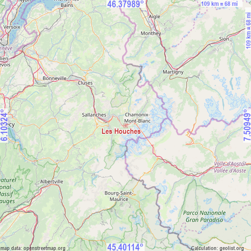
Les Houches GPS coordinates[2]
45° 53' 33.612" North, 6° 48' 22.932" East
| Map corner | latitude | longitude |
|---|---|---|
| Upper-left | 46.37989°, | 6.10324° |
| Center: | 45.89267°, | 6.80637° |
| Lower-right: | 45.40114°, | 7.50949° |
| Map W x H: | 108.8×108.8 km | = 67.6×67.6mi |
| max Lat: | 51.07786° ⇑67.8% North |
| Les Houches: | 45.89267° |
| min Lat: | ⇓32.2% South 41.3874° |
| min Long | Les Houches | max Long |
| -5.08615° | 6.80637° | 9.52242° |
| W 93.7%⇐ | ⇒6.3% E |
Elevation
Elevation of Les Houches is 1010 m = 3314 ft, and this is 816.3 m = 2678 ft above average elevation for this country.
| Max E: |
2333 m = 7654 ft | 0.90000000000001% |
| Les Houches | 1010 m 3314 ft | |
| Avg. | 193.7 m = 635 ft | |
Min E: |
-1 m = -3 ft | 99.1% |
See also: France elevation on elevation.city.
Geographical zone
Les Houches is located in North temperate zone (between Tropic of Cancer and the Arctic Circle). Distance of this North polar circle is 2298.4 km =1428.2 mi to North.| Distance of | km | miles | from Les Houches |
|---|---|---|---|
| North Pole | 4904.3 | 3047.4 | to North |
| Arctic Circle | 2298.4 | 1428.2 | to North |
| Tropic Cancer | 2496.9 | 1551.5 | to South |
| Equator | 5102.8 | 3170.7 | to South |


Nearby cities:
15 places around Les Houches: (largest is in red/bold)
• Arâches-la-Frasse
21.5 km =13.4 mi,  321°
321°
• Chamonix-Mont-Blanc
6 km =3.7 mi,  54°
54°
• Combloux
12.6 km =7.8 mi,  272°
272°
• Cordon
15.9 km =9.9 mi,  281°
281°
• Domancy
12.1 km =7.5 mi, 280°
• Les Contamines-Montjoie
9.9 km =6.2 mi,  217°
217°
• Magland
20.2 km =12.6 mi,  314°
314°
• Megève
15.1 km =9.4 mi,  254°
254°
• Morillon
23.5 km =14.6 mi,  334°
334°
• Passy
9.2 km =5.7 mi,  291°
291°
• Praz-sur-Arly
19.1 km =11.9 mi, 251°
• Saint-Gervais-les-Bains
6.9 km =4.3 mi, 268°
• Sallanches
14.7 km =9.1 mi, 292°
• Samoëns
22 km =13.7 mi,  343°
343°
• Servoz
5.5 km =3.4 mi, 321°
Sources, notices
• [Note1] Compared only with cities in France existing in our database
• [Src1] Map data: © OpenStreetMap contributors (CC-BY-SA)
• [Src2] Other city data from geonames.org with taken over terms of usage.
• [Src3] Geographical zone / Annual Mean Temperature by Robert A. Rohde @ Wikipedia
