Saissac geodata
Saissac (Occitanie) is a populated place; located in France in Europe/Paris (GMT+2) time zone. With population of 985 people, there are 8948 cities with bigger population in this country. Compared to other cities in France, 94.7% of cities are located further ↑North; 54.9% of cities are located further →East and 91.8% of cities have lower elevation than Saissac. Note1
Administrative division(s):
- Level 1: Occitanie
- Level 2: Département de l'Aude
- Level 3: Arrondissement de Carcassonne
- Level 4: Saissac


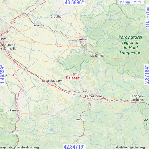
Saissac GPS coordinates[2]
43° 21' 37.98" North, 2° 10' 7.356" East
| Map corner | latitude | longitude |
|---|---|---|
| Upper-left | 43.8696°, | 1.46559° |
| Center: | 43.36055°, | 2.16871° |
| Lower-right: | 42.84719°, | 2.87184° |
| Map W x H: | 113.7×113.7 km | = 70.6×70.6mi |
| max Lat: | 51.07786° ⇑94.7% North |
| Saissac: | 43.36055° |
| min Lat: | ⇓5.3% South 41.3874° |
| min Long | Saissac | max Long |
| -5.08615° | 2.16871° | 9.52242° |
| W 45.1%⇐ | ⇒54.9% E |
Elevation
Elevation of Saissac is 470 m = 1542 ft, and this is 276.3 m = 906 ft above average elevation for this country.
| Max E: |
2333 m = 7654 ft | 8.2% |
| Saissac | 470 m 1542 ft | |
| Avg. | 193.7 m = 635 ft | |
Min E: |
-1 m = -3 ft | 91.8% |
See also: France elevation on elevation.city.
Geographical zone
Saissac is located in North temperate zone (between Tropic of Cancer and the Arctic Circle). Distance of this Northern Tropic circle is 2215.3 km =1376.5 mi to South.| Distance of | km | miles | from Saissac |
|---|---|---|---|
| North Pole | 5185.8 | 3222.3 | to North |
| Arctic Circle | 2579.9 | 1603.1 | to North |
| Tropic Cancer | 2215.3 | 1376.5 | to South |
| Equator | 4821.2 | 2995.8 | to South |


Nearby cities:
15 places around Saissac: (largest is in red/bold)
• Alzonne
11.9 km =7.4 mi,  176°
176°
• Bram
13.7 km =8.5 mi,  199°
199°
• Cuxac-Cabardès
9.4 km =5.8 mi,  82°
82°
• Dourgne
13.9 km =8.6 mi,  350°
350°
• Lasbordes
12.4 km =7.7 mi,  233°
233°
• Montolieu
6.7 km =4.2 mi,  146°
146°
• Moussoulens
10.3 km =6.4 mi, 150°
• Pexiora
14.8 km =9.2 mi, 226°
• Pezens
14.3 km =8.9 mi, 145°
• Saint-Martin-Lalande
13.8 km =8.6 mi,  240°
240°
• Saint-Papoul
11.2 km =7 mi,  252°
252°
• Sorèze
13.1 km =8.1 mi,  321°
321°
• Ventenac-Cabardès
14.1 km =8.8 mi,  138°
138°
• Villepinte
10.9 km =6.8 mi,  216°
216°
• Villesèquelande
15.1 km =9.4 mi,  159°
159°
Sources, notices
• [Note1] Compared only with cities in France existing in our database
• [Src1] Map data: © OpenStreetMap contributors (CC-BY-SA)
• [Src2] Other city data from geonames.org with taken over terms of usage.
• [Src3] Geographical zone / Annual Mean Temperature by Robert A. Rohde @ Wikipedia
