Saint-Vivien geodata
Saint-Vivien (Nouvelle-Aquitaine) is a populated place; located in France in Europe/Paris (GMT+2) time zone. With population of 902 people, there are 9633 cities with bigger population in this country. Compared to other cities in France, 65.3% of cities are located further ↑North; 88.7% of cities are located further →East and 99.6% of cities have higher elevation than Saint-Vivien. Note1
Administrative division(s):
- Level 1: Nouvelle-Aquitaine
- Level 2: Charente-Maritime
- Level 3: Arrondissement de La Rochelle
- Level 4: Saint-Vivien


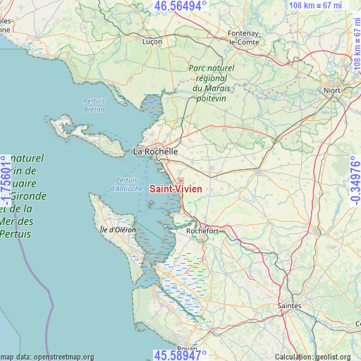
Saint-Vivien GPS coordinates[2]
46° 4' 45.696" North, 1° 3' 10.404" West
| Map corner | latitude | longitude |
|---|---|---|
| Upper-left | 46.56494°, | -1.75601° |
| Center: | 46.07936°, | -1.05289° |
| Lower-right: | 45.58947°, | -0.34976° |
| Map W x H: | 108.5×108.5 km | = 67.4×67.4mi |
| max Lat: | 51.07786° ⇑65.3% North |
| Saint-Vivien: | 46.07936° |
| min Lat: | ⇓34.7% South 41.3874° |
| min Long | Saint-Vivien | max Long |
| -5.08615° | -1.05289° | 9.52242° |
| W 11.3%⇐ | ⇒88.7% E |
Elevation
Elevation of Saint-Vivien is 4 m = 13 ft, and this is 189.7 m = 622 ft below average elevation for this country.
| Max E: |
2333 m = 7654 ft | 99.6% |
| Avg. | 193.7 m = 635 ft | |
| Saint-Vivien | 4 m = 13 ft | |
Min E: |
-1 m = -3 ft | 0.4% |
See also: France elevation on elevation.city.
Geographical zone
Saint-Vivien is located in North temperate zone (between Tropic of Cancer and the Arctic Circle). Distance of this North polar circle is 2277.6 km =1415.2 mi to North.| Distance of | km | miles | from Saint-Vivien |
|---|---|---|---|
| North Pole | 4883.5 | 3034.5 | to North |
| Arctic Circle | 2277.6 | 1415.2 | to North |
| Tropic Cancer | 2517.6 | 1564.4 | to South |
| Equator | 5123.5 | 3183.6 | to South |


Nearby cities:
15 places around Saint-Vivien: (largest is in red/bold)
• Angoulins
5.1 km =3.2 mi,  304°
304°
• Aytré
7.9 km =4.9 mi,  322°
322°
• Ballon
8.2 km =5.1 mi,  107°
107°
• Châtelaillon-Plage
2.9 km =1.8 mi,  253°
253°
• Ciré-d’Aunis
9.8 km =6.1 mi, 105°
• Clavette
7.1 km =4.4 mi,  15°
15°
• Croix-Chapeau
4.7 km =2.9 mi,  43°
43°
• La Jarne
5.6 km =3.5 mi,  344°
344°
• La Jarrie
6.5 km =4 mi,  31°
31°
• Montroy
9.1 km =5.7 mi, 20°
• Périgny
9.1 km =5.7 mi, 337°
• Saint-Rogatien
8 km =5 mi,  350°
350°
• Salles-sur-Mer
2.9 km =1.8 mi, 353°
• Thairé
4 km =2.5 mi,  99°
99°
• Yves
6.7 km =4.2 mi,  176°
176°
Sources, notices
• [Note1] Compared only with cities in France existing in our database
• [Src1] Map data: © OpenStreetMap contributors (CC-BY-SA)
• [Src2] Other city data from geonames.org with taken over terms of usage.
• [Src3] Geographical zone / Annual Mean Temperature by Robert A. Rohde @ Wikipedia
