Yves geodata
Yves (Nouvelle-Aquitaine) is a populated place; located in France in Europe/Paris (GMT+2) time zone. With population of 1,128 people, there are 7959 cities with bigger population in this country. Compared to other cities in France, 66% of cities are located further ↑North; 88.6% of cities are located further →East and 98.2% of cities have higher elevation than Yves. Note1
Administrative division(s):
- Level 1: Nouvelle-Aquitaine
- Level 2: Charente-Maritime
- Level 3: Arrondissement de La Rochelle
- Level 4: Yves


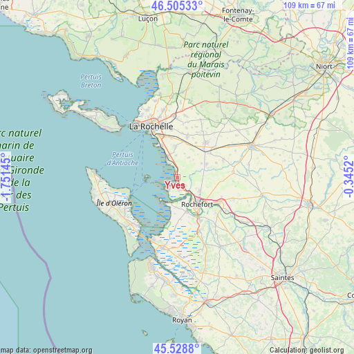
Yves GPS coordinates[2]
46° 1' 9.192" North, 1° 2' 53.988" West
| Map corner | latitude | longitude |
|---|---|---|
| Upper-left | 46.50533°, | -1.75145° |
| Center: | 46.01922°, | -1.04833° |
| Lower-right: | 45.5288°, | -0.3452° |
| Map W x H: | 108.6×108.6 km | = 67.5×67.5mi |
| max Lat: | 51.07786° ⇑66% North |
| Yves: | 46.01922° |
| min Lat: | ⇓34% South 41.3874° |
| min Long | Yves | max Long |
| -5.08615° | -1.04833° | 9.52242° |
| W 11.4%⇐ | ⇒88.6% E |
Elevation
Elevation of Yves is 8 m = 26 ft, and this is 185.7 m = 609 ft below average elevation for this country.
| Max E: |
2333 m = 7654 ft | 98.2% |
| Avg. | 193.7 m = 635 ft | |
| Yves | 8 m = 26 ft | |
Min E: |
-1 m = -3 ft | 1.8% |
See also: France elevation on elevation.city.
Geographical zone
Yves is located in North temperate zone (between Tropic of Cancer and the Arctic Circle). Distance of this North polar circle is 2284.3 km =1419.4 mi to North.| Distance of | km | miles | from Yves |
|---|---|---|---|
| North Pole | 4890.2 | 3038.6 | to North |
| Arctic Circle | 2284.3 | 1419.4 | to North |
| Tropic Cancer | 2510.9 | 1560.2 | to South |
| Equator | 5116.9 | 3179.5 | to South |


Nearby cities:
15 places around Yves: (largest is in red/bold)
• Angoulins
10.6 km =6.6 mi,  334°
334°
• Ballon
8.6 km =5.3 mi,  60°
60°
• Breuil-Magné
7.8 km =4.8 mi,  119°
119°
• Châtelaillon-Plage
6.7 km =4.2 mi, 331°
• Ciré-d’Aunis
9.9 km =6.2 mi,  66°
66°
• Croix-Chapeau
10.5 km =6.5 mi,  16°
16°
• Fouras
4.9 km =3 mi,  224°
224°
• Port-des-Barques
8.3 km =5.2 mi,  196°
196°
• Rochefort
10.6 km =6.6 mi,  143°
143°
• Saint-Laurent-de-la-Prée
4.2 km =2.6 mi,  167°
167°
• Saint-Nazaire-sur-Charente
9.2 km =5.7 mi,  181°
181°
• Saint-Vivien
6.7 km =4.2 mi,  356°
356°
• Salles-sur-Mer
9.6 km =6 mi, 355°
• Thairé
7 km =4.3 mi,  30°
30°
• Vergeroux
7.7 km =4.8 mi, 139°
Sources, notices
• [Note1] Compared only with cities in France existing in our database
• [Src1] Map data: © OpenStreetMap contributors (CC-BY-SA)
• [Src2] Other city data from geonames.org with taken over terms of usage.
• [Src3] Geographical zone / Annual Mean Temperature by Robert A. Rohde @ Wikipedia
