Aytré geodata
Aytré (Nouvelle-Aquitaine) is a populated place; located in France in Europe/Paris (GMT+2) time zone. With population of 8,335 people, there are 1161 cities with bigger population in this country. Compared to other cities in France, 64.6% of cities are located further ↑North; 89.3% of cities are located further →East and 96.3% of cities have higher elevation than Aytré. Note1
Administrative division(s):
- Level 1: Nouvelle-Aquitaine
- Level 2: Charente-Maritime
- Level 3: Arrondissement de La Rochelle
- Level 4: Aytré


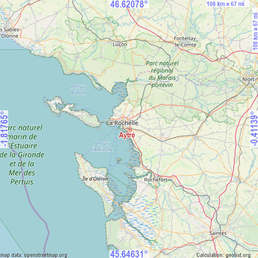
Aytré GPS coordinates[2]
46° 8' 8.52" North, 1° 6' 52.272" West
| Map corner | latitude | longitude |
|---|---|---|
| Upper-left | 46.62078°, | -1.81765° |
| Center: | 46.1357°, | -1.11452° |
| Lower-right: | 45.64631°, | -0.41139° |
| Map W x H: | 108.4×108.3 km | = 67.4×67.3mi |
| max Lat: | 51.07786° ⇑64.6% North |
| Aytré: | 46.1357° |
| min Lat: | ⇓35.4% South 41.3874° |
| min Long | Aytré | max Long |
| -5.08615° | -1.11452° | 9.52242° |
| W 10.7%⇐ | ⇒89.3% E |
Elevation
Elevation of Aytré is 13 m = 43 ft, and this is 180.7 m = 593 ft below average elevation for this country.
| Max E: |
2333 m = 7654 ft | 96.3% |
| Avg. | 193.7 m = 635 ft | |
| Aytré | 13 m = 43 ft | |
Min E: |
-1 m = -3 ft | 3.7% |
See also: France elevation on elevation.city.
Geographical zone
Aytré is located in North temperate zone (between Tropic of Cancer and the Arctic Circle). Distance of this North polar circle is 2271.4 km =1411.4 mi to North.| Distance of | km | miles | from Aytré |
|---|---|---|---|
| North Pole | 4877.3 | 3030.6 | to North |
| Arctic Circle | 2271.4 | 1411.4 | to North |
| Tropic Cancer | 2523.9 | 1568.3 | to South |
| Equator | 5129.8 | 3187.5 | to South |


Nearby cities:
15 places around Aytré: (largest is in red/bold)
• Angoulins
3.4 km =2.1 mi,  170°
170°
• Bourgneuf
8 km =5 mi,  63°
63°
• Châtelaillon-Plage
7.4 km =4.6 mi,  164°
164°
• Clavette
6.7 km =4.2 mi,  85°
85°
• Dompierre-sur-Mer
7 km =4.3 mi,  33°
33°
• La Jarne
3.4 km =2.1 mi,  105°
105°
• La Jarrie
8.2 km =5.1 mi,  95°
95°
• La Rochelle
4.4 km =2.7 mi,  321°
321°
• Lagord
6.6 km =4.1 mi,  332°
332°
• Puilboreau
5.6 km =3.5 mi,  357°
357°
• Périgny
2.5 km =1.6 mi, 30°
• Saint-Rogatien
3.8 km =2.4 mi,  65°
65°
• Saint-Vivien
7.9 km =4.9 mi,  142°
142°
• Saint-Xandre
7.7 km =4.8 mi,  6°
6°
• Salles-sur-Mer
5.5 km =3.4 mi,  127°
127°
Sources, notices
• [Note1] Compared only with cities in France existing in our database
• [Src1] Map data: © OpenStreetMap contributors (CC-BY-SA)
• [Src2] Other city data from geonames.org with taken over terms of usage.
• [Src3] Geographical zone / Annual Mean Temperature by Robert A. Rohde @ Wikipedia
