Saint-Révérend geodata
Saint-Révérend (Pays de la Loire) is a populated place; located in France in Europe/Paris (GMT+2) time zone. With population of 968 people, there are 9076 cities with bigger population in this country. Compared to other cities in France, 58.2% of cities are located further ↑North; 94.2% of cities are located further →East and 95.7% of cities have higher elevation than Saint-Révérend. Note1
Administrative division(s):
- Level 1: Pays de la Loire
- Level 2: Département de la Vendée
- Level 3: Arrondissement des Sables-d'Olonne
- Level 4: Saint-Révérend


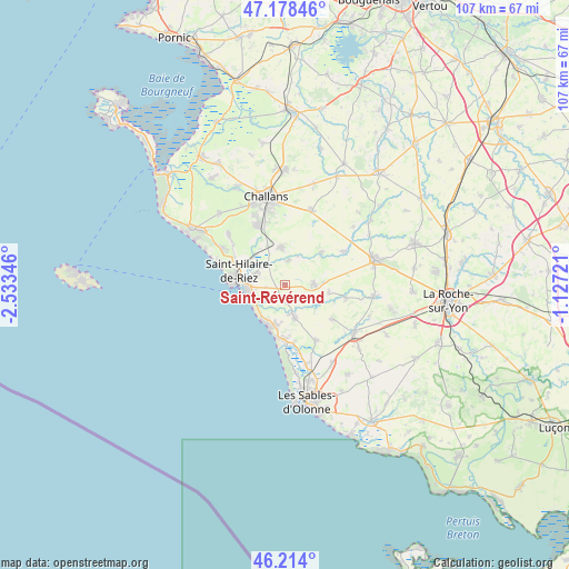
Saint-Révérend GPS coordinates[2]
46° 41' 54.168" North, 1° 49' 49.188" West
| Map corner | latitude | longitude |
|---|---|---|
| Upper-left | 47.17846°, | -2.53346° |
| Center: | 46.69838°, | -1.83033° |
| Lower-right: | 46.214°, | -1.12721° |
| Map W x H: | 107.2×107.2 km | = 66.6×66.6mi |
| max Lat: | 51.07786° ⇑58.2% North |
| Saint-Révérend: | 46.69838° |
| min Lat: | ⇓41.8% South 41.3874° |
| min Long | Saint-Révéren | max Long |
| -5.08615° | -1.83033° | 9.52242° |
| W 5.8%⇐ | ⇒94.2% E |
Elevation
Elevation of Saint-Révérend is 15 m = 49 ft, and this is 178.7 m = 586 ft below average elevation for this country.
| Max E: |
2333 m = 7654 ft | 95.7% |
| Avg. | 193.7 m = 635 ft | |
| Saint-Révérend | 15 m = 49 ft | |
Min E: |
-1 m = -3 ft | 4.3% |
See also: France elevation on elevation.city.
Geographical zone
Saint-Révérend is located in North temperate zone (between Tropic of Cancer and the Arctic Circle). Distance of this North polar circle is 2208.8 km =1372.5 mi to North.| Distance of | km | miles | from Saint-Révérend |
|---|---|---|---|
| North Pole | 4814.7 | 2991.7 | to North |
| Arctic Circle | 2208.8 | 1372.5 | to North |
| Tropic Cancer | 2586.5 | 1607.2 | to South |
| Equator | 5192.4 | 3226.4 | to South |


Nearby cities:
15 places around Saint-Révérend: (largest is in red/bold)
• Apremont
8.8 km =5.5 mi,  50°
50°
• Bretignolles-sur-Mer
7.7 km =4.8 mi,  200°
200°
• Commequiers
6.9 km =4.3 mi,  354°
354°
• Coëx
5.4 km =3.4 mi,  90°
90°
• Givrand
5.2 km =3.2 mi,  234°
234°
• La Chaize-Giraud
5.8 km =3.6 mi,  169°
169°
• La Chapelle-Hermier
8.4 km =5.2 mi,  101°
101°
• Landevieille
6.6 km =4.1 mi,  164°
164°
• Le Fenouiller
5.9 km =3.7 mi,  292°
292°
• Martinet
11.6 km =7.2 mi, 102°
• Notre-Dame-de-Riez
7.9 km =4.9 mi,  310°
310°
• Saint-Gilles-Croix-de-Vie
8.8 km =5.5 mi,  269°
269°
• Saint-Hilaire-de-Riez
7.5 km =4.7 mi,  282°
282°
• Saint-Julien-des-Landes
11 km =6.8 mi,  126°
126°
• Saint-Maixent-sur-Vie
4.6 km =2.9 mi,  6°
6°
Sources, notices
• [Note1] Compared only with cities in France existing in our database
• [Src1] Map data: © OpenStreetMap contributors (CC-BY-SA)
• [Src2] Other city data from geonames.org with taken over terms of usage.
• [Src3] Geographical zone / Annual Mean Temperature by Robert A. Rohde @ Wikipedia
