Apremont geodata
Apremont (Pays de la Loire) is a populated place; located in France in Europe/Paris (GMT+2) time zone. With population of 1,199 people, there are 7541 cities with bigger population in this country. Compared to other cities in France, 57.7% of cities are located further ↑North; 93.7% of cities are located further →East and 95% of cities have higher elevation than Apremont. Note1
Administrative division(s):
- Level 1: Pays de la Loire
- Level 2: Département de la Vendée
- Level 3: Arrondissement de La Roche-sur-Yon
- Level 4: Apremont


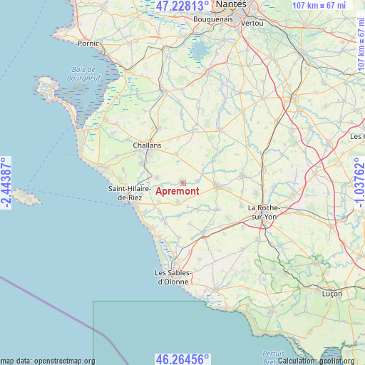
Apremont GPS coordinates[2]
46° 44' 54.6" North, 1° 44' 26.7" West
| Map corner | latitude | longitude |
|---|---|---|
| Upper-left | 47.22813°, | -2.44387° |
| Center: | 46.7485°, | -1.74075° |
| Lower-right: | 46.26456°, | -1.03762° |
| Map W x H: | 107.1×107.1 km | = 66.5×66.5mi |
| max Lat: | 51.07786° ⇑57.7% North |
| Apremont: | 46.7485° |
| min Lat: | ⇓42.3% South 41.3874° |
| min Long | Apremont | max Long |
| -5.08615° | -1.74075° | 9.52242° |
| W 6.3%⇐ | ⇒93.7% E |
Elevation
Elevation of Apremont is 17 m = 56 ft, and this is 176.7 m = 580 ft below average elevation for this country.
| Max E: |
2333 m = 7654 ft | 95% |
| Avg. | 193.7 m = 635 ft | |
| Apremont | 17 m = 56 ft | |
Min E: |
-1 m = -3 ft | 5% |
See also: France elevation on elevation.city.
Geographical zone
Apremont is located in North temperate zone (between Tropic of Cancer and the Arctic Circle). Distance of this North polar circle is 2203.2 km =1369 mi to North.| Distance of | km | miles | from Apremont |
|---|---|---|---|
| North Pole | 4809.1 | 2988.2 | to North |
| Arctic Circle | 2203.2 | 1369 | to North |
| Tropic Cancer | 2592 | 1610.6 | to South |
| Equator | 5197.9 | 3229.8 | to South |


Nearby cities:
15 places around Apremont: (largest is in red/bold)
• Aizenay
10.1 km =6.3 mi,  95°
95°
• Beaulieu-sous-la-Roche
12.7 km =7.9 mi,  129°
129°
• Commequiers
7.6 km =4.7 mi,  280°
280°
• Coëx
5.8 km =3.6 mi,  194°
194°
• La Chaize-Giraud
12.7 km =7.9 mi,  207°
207°
• La Chapelle-Hermier
7.5 km =4.7 mi,  168°
168°
• La Chapelle-Palluau
9.8 km =6.1 mi,  67°
67°
• Maché
4.1 km =2.5 mi,  81°
81°
• Martinet
9.3 km =5.8 mi,  150°
150°
• Palluau
11.1 km =6.9 mi,  55°
55°
• Saint-Christophe-du-Ligneron
8.7 km =5.4 mi,  347°
347°
• Saint-Julien-des-Landes
12.3 km =7.6 mi, 170°
• Saint-Maixent-sur-Vie
6.4 km =4 mi,  261°
261°
• Saint-Paul-Mont-Penit
8 km =5 mi,  47°
47°
• Saint-Révérend
8.8 km =5.5 mi,  230°
230°
Sources, notices
• [Note1] Compared only with cities in France existing in our database
• [Src1] Map data: © OpenStreetMap contributors (CC-BY-SA)
• [Src2] Other city data from geonames.org with taken over terms of usage.
• [Src3] Geographical zone / Annual Mean Temperature by Robert A. Rohde @ Wikipedia
