Saint-Quentin-la-Poterie geodata
Saint-Quentin-la-Poterie (Occitanie) is a populated place; located in France in Europe/Paris (GMT+2) time zone. With population of 2,986 people, there are 3267 cities with bigger population in this country. Compared to other cities in France, 86.7% of cities are located further ↑North; 71.7% of cities are located further ←West and 57.6% of cities have higher elevation than Saint-Quentin-la-Poterie. Note1
Administrative division(s):
- Level 1: Occitanie
- Level 2: Gard
- Level 3: Arrondissement de Nîmes
- Level 4: Saint-Quentin-la-Poterie
Current local time in Saint-Quentin-la-Poterie:
02:48 AM, SundayDifference from your time zone: hours


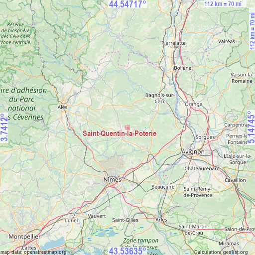
Saint-Quentin-la-Poterie GPS coordinates[2]
44° 2' 38.112" North, 4° 26' 39.552" East
| Map corner | latitude | longitude |
|---|---|---|
| Upper-left | 44.54717°, | 3.7412° |
| Center: | 44.04392°, | 4.44432° |
| Lower-right: | 43.53635°, | 5.14745° |
| Map W x H: | 112.4×112.4 km | = 69.8×69.8mi |
| max Lat: | 51.07786° ⇑86.7% North |
| Saint-Quentin-la-Poterie: | 44.04392° |
| min Lat: | ⇓13.3% South 41.3874° |
| min Long | Saint-Quentin-l | max Long |
| -5.08615° | 4.44432° | 9.52242° |
| W 71.7%⇐ | ⇒28.3% E |
Elevation
Elevation of Saint-Quentin-la-Poterie is 109 m = 358 ft, and this is 84.7 m = 278 ft below average elevation for this country.
| Max E: |
2333 m = 7654 ft | 57.6% |
| Avg. | 193.7 m = 635 ft | |
| Saint-Quentin-la-Poterie | 109 m = 358 ft | |
Min E: |
-1 m = -3 ft | 42.4% |
See also: France elevation on elevation.city.
Geographical zone
Saint-Quentin-la-Poterie is located in North temperate zone (between Tropic of Cancer and the Arctic Circle). Distance of this Northern Tropic circle is 2291.3 km =1423.7 mi to South.| Distance of | km | miles | from Saint-Quentin-la-Poterie |
|---|---|---|---|
| North Pole | 5109.8 | 3175.1 | to North |
| Arctic Circle | 2503.9 | 1555.9 | to North |
| Tropic Cancer | 2291.3 | 1423.7 | to South |
| Equator | 4897.2 | 3043 | to South |


Nearby cities:
15 places around Saint-Quentin-la-Poterie: (largest is in red/bold)
• Arpaillargues-et-Aureillac
7.5 km =4.7 mi,  230°
230°
• Blauzac
11 km =6.8 mi,  213°
213°
• Castillon-du-Gard
12.4 km =7.7 mi,  135°
135°
• Cavillargues
10 km =6.2 mi,  38°
38°
• Collias
10.2 km =6.3 mi,  164°
164°
• Garrigues-Sainte-Eulalie
12.2 km =7.6 mi,  236°
236°
• Gaujac
11.4 km =7.1 mi,  68°
68°
• Montaren-et-Saint-Médiers
5.4 km =3.4 mi,  251°
251°
• Sagriès
7.5 km =4.7 mi,  195°
195°
• Saint-Laurent-la-Vernède
7 km =4.3 mi,  9°
9°
• Saint-Marcel-de-Careiret
11.3 km =7 mi,  17°
17°
• Saint-Maximin
5.5 km =3.4 mi,  174°
174°
• Saint-Siffret
4.3 km =2.7 mi,  150°
150°
• Uzès
4.1 km =2.5 mi, 214°
• Vers-Pont-du-Gard
11.2 km =7 mi, 140°
Sources, notices
• [Note1] Compared only with cities in France existing in our database
• [Src1] Map data: © OpenStreetMap contributors (CC-BY-SA)
• [Src2] Other city data from geonames.org with taken over terms of usage.
• [Src3] Geographical zone / Annual Mean Temperature by Robert A. Rohde @ Wikipedia
