Blauzac geodata
Blauzac (Occitanie) is a populated place; located in France in Europe/Paris (GMT+2) time zone. With population of 1,031 people, there are 8609 cities with bigger population in this country. Compared to other cities in France, 87.4% of cities are located further ↑North; 71.1% of cities are located further ←West and 55.2% of cities have higher elevation than Blauzac. Note1
Administrative division(s):
- Level 1: Occitanie
- Level 2: Gard
- Level 3: Arrondissement de Nîmes
- Level 4: Blauzac


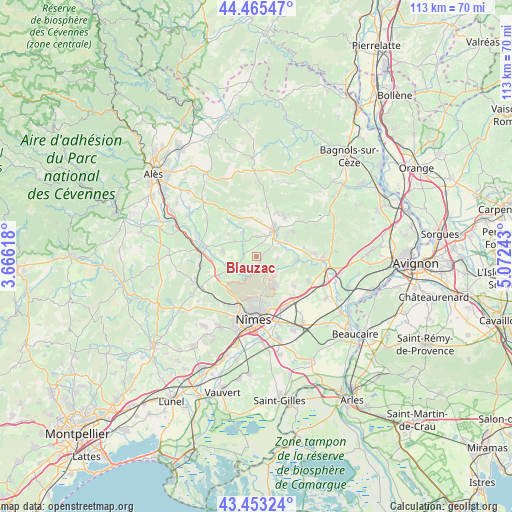
Blauzac GPS coordinates[2]
43° 57' 41.436" North, 4° 22' 9.48" East
| Map corner | latitude | longitude |
|---|---|---|
| Upper-left | 44.46547°, | 3.66618° |
| Center: | 43.96151°, | 4.3693° |
| Lower-right: | 43.45324°, | 5.07243° |
| Map W x H: | 112.5×112.5 km | = 69.9×69.9mi |
| max Lat: | 51.07786° ⇑87.4% North |
| Blauzac: | 43.96151° |
| min Lat: | ⇓12.6% South 41.3874° |
| min Long | Blauzac | max Long |
| -5.08615° | 4.3693° | 9.52242° |
| W 71.1%⇐ | ⇒28.9% E |
Elevation
Elevation of Blauzac is 116 m = 381 ft, and this is 77.7 m = 255 ft below average elevation for this country.
| Max E: |
2333 m = 7654 ft | 55.2% |
| Avg. | 193.7 m = 635 ft | |
| Blauzac | 116 m = 381 ft | |
Min E: |
-1 m = -3 ft | 44.8% |
See also: France elevation on elevation.city.
Geographical zone
Blauzac is located in North temperate zone (between Tropic of Cancer and the Arctic Circle). Distance of this Northern Tropic circle is 2282.1 km =1418 mi to South.| Distance of | km | miles | from Blauzac |
|---|---|---|---|
| North Pole | 5119 | 3180.8 | to North |
| Arctic Circle | 2513.1 | 1561.6 | to North |
| Tropic Cancer | 2282.1 | 1418 | to South |
| Equator | 4888.1 | 3037.3 | to South |


Nearby cities:
15 places around Blauzac: (largest is in red/bold)
• Arpaillargues-et-Aureillac
4.4 km =2.7 mi,  3°
3°
• Cabrières
10.4 km =6.5 mi,  128°
128°
• Collias
8.7 km =5.4 mi,  94°
94°
• Dions
6.7 km =4.2 mi,  240°
240°
• Garrigues-Sainte-Eulalie
4.9 km =3 mi,  299°
299°
• La Calmette
9.3 km =5.8 mi, 242°
• La Rouvière
11.4 km =7.1 mi,  252°
252°
• Montaren-et-Saint-Médiers
7.5 km =4.7 mi,  6°
6°
• Poulx
7 km =4.3 mi,  147°
147°
• Sagriès
4.5 km =2.8 mi,  64°
64°
• Saint-Chaptes
7.4 km =4.6 mi,  278°
278°
• Saint-Maximin
7.5 km =4.7 mi, 60°
• Saint-Quentin-la-Poterie
11 km =6.8 mi,  33°
33°
• Saint-Siffret
9.7 km =6 mi, 56°
• Uzès
6.9 km =4.3 mi, 32°
Sources, notices
• [Note1] Compared only with cities in France existing in our database
• [Src1] Map data: © OpenStreetMap contributors (CC-BY-SA)
• [Src2] Other city data from geonames.org with taken over terms of usage.
• [Src3] Geographical zone / Annual Mean Temperature by Robert A. Rohde @ Wikipedia
