Montaren-et-Saint-Médiers geodata
Montaren-et-Saint-Médiers (Occitanie) is a populated place; located in France in Europe/Paris (GMT+2) time zone. With population of 1,354 people, there are 6792 cities with bigger population in this country. Compared to other cities in France, 86.9% of cities are located further ↑North; 71.3% of cities are located further ←West and 55.6% of cities have higher elevation than Montaren-et-Saint-Médiers. Note1
Administrative division(s):
- Level 1: Occitanie
- Level 2: Gard
- Level 3: Arrondissement de Nîmes
- Level 4: Montaren-et-Saint-Médiers
Current local time in Montaren-et-Saint-Médiers:
02:53 AM, SundayDifference from your time zone: hours


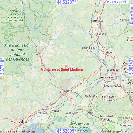
Montaren-et-Saint-Médiers GPS coordinates[2]
44° 1' 43.284" North, 4° 22' 49.08" East
| Map corner | latitude | longitude |
|---|---|---|
| Upper-left | 44.53207°, | 3.67718° |
| Center: | 44.02869°, | 4.3803° |
| Lower-right: | 43.52099°, | 5.08343° |
| Map W x H: | 112.4×112.4 km | = 69.8×69.8mi |
| max Lat: | 51.07786° ⇑86.9% North |
| Montaren-et-Saint-Médiers: | 44.02869° |
| min Lat: | ⇓13.1% South 41.3874° |
| min Long | Montaren-et-Sai | max Long |
| -5.08615° | 4.3803° | 9.52242° |
| W 71.3%⇐ | ⇒28.7% E |
Elevation
Elevation of Montaren-et-Saint-Médiers is 115 m = 377 ft, and this is 78.7 m = 258 ft below average elevation for this country.
| Max E: |
2333 m = 7654 ft | 55.6% |
| Avg. | 193.7 m = 635 ft | |
| Montaren-et-Saint-Médiers | 115 m = 377 ft | |
Min E: |
-1 m = -3 ft | 44.4% |
See also: France elevation on elevation.city.
Geographical zone
Montaren-et-Saint-Médiers is located in North temperate zone (between Tropic of Cancer and the Arctic Circle). Distance of this Northern Tropic circle is 2289.6 km =1422.7 mi to South.| Distance of | km | miles | from Montaren-et-Saint-Médiers |
|---|---|---|---|
| North Pole | 5111.5 | 3176.1 | to North |
| Arctic Circle | 2505.6 | 1556.9 | to North |
| Tropic Cancer | 2289.6 | 1422.7 | to South |
| Equator | 4895.5 | 3041.9 | to South |


Nearby cities:
15 places around Montaren-et-Saint-Médiers: (largest is in red/bold)
• Arpaillargues-et-Aureillac
3.2 km =2 mi,  191°
191°
• Blauzac
7.5 km =4.7 mi, 186°
• Collias
11.3 km =7 mi,  136°
136°
• Dions
12.7 km =7.9 mi,  211°
211°
• Garrigues-Sainte-Eulalie
7.2 km =4.5 mi,  225°
225°
• Moussac
13.4 km =8.3 mi,  246°
246°
• Poulx
13.7 km =8.5 mi,  167°
167°
• Sagriès
6.4 km =4 mi,  150°
150°
• Saint-Chaptes
10.3 km =6.4 mi, 232°
• Saint-Laurent-la-Vernède
10.7 km =6.6 mi,  36°
36°
• Saint-Maurice-de-Cazevieille
11.7 km =7.3 mi,  270°
270°
• Saint-Maximin
6.8 km =4.2 mi,  123°
123°
• Saint-Quentin-la-Poterie
5.4 km =3.4 mi,  71°
71°
• Saint-Siffret
7.5 km =4.7 mi,  105°
105°
• Uzès
3.3 km =2.1 mi, 120°
Sources, notices
• [Note1] Compared only with cities in France existing in our database
• [Src1] Map data: © OpenStreetMap contributors (CC-BY-SA)
• [Src2] Other city data from geonames.org with taken over terms of usage.
• [Src3] Geographical zone / Annual Mean Temperature by Robert A. Rohde @ Wikipedia
