Saint-Philbert-sur-Risle geodata
Saint-Philbert-sur-Risle (Normandy) is a populated place; located in France in Europe/Paris (GMT+2) time zone. With population of 832 people, there are 10268 cities with bigger population in this country. Compared to other cities in France, 86% of cities are located further ↓South; 71.9% of cities are located further →East and 86.7% of cities have higher elevation than Saint-Philbert-sur-Risle. Note1
Administrative division(s):
- Level 1: Normandy
- Level 2: Département de l'Eure
- Level 3: Arrondissement de Bernay
- Level 4: Saint-Philbert-sur-Risle
Current local time in Saint-Philbert-sur-Risle:
09:57 AM, SaturdayDifference from your time zone: hours


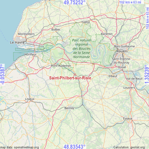
Saint-Philbert-sur-Risle GPS coordinates[2]
49° 17' 45.996" North, 0° 38' 57.336" East
| Map corner | latitude | longitude |
|---|---|---|
| Upper-left | 49.75252°, | -0.05387° |
| Center: | 49.29611°, | 0.64926° |
| Lower-right: | 48.83543°, | 1.35239° |
| Map W x H: | 102×102 km | = 63.4×63.4mi |
| max Lat: | 51.07786° ⇑14% North |
| Saint-Philbert-sur-Risle: | 49.29611° |
| min Lat: | ⇓86% South 41.3874° |
| min Long | Saint-Philbert- | max Long |
| -5.08615° | 0.64926° | 9.52242° |
| W 28.1%⇐ | ⇒71.9% E |
Elevation
Elevation of Saint-Philbert-sur-Risle is 38 m = 125 ft, and this is 155.7 m = 511 ft below average elevation for this country.
| Max E: |
2333 m = 7654 ft | 86.7% |
| Avg. | 193.7 m = 635 ft | |
| Saint-Philbert-sur-Risle | 38 m = 125 ft | |
Min E: |
-1 m = -3 ft | 13.3% |
See also: France elevation on elevation.city.
Geographical zone
Saint-Philbert-sur-Risle is located in North temperate zone (between Tropic of Cancer and the Arctic Circle). Distance of this North polar circle is 1920 km =1193 mi to North.| Distance of | km | miles | from Saint-Philbert-sur-Risle |
|---|---|---|---|
| North Pole | 4525.8 | 2812.2 | to North |
| Arctic Circle | 1920 | 1193 | to North |
| Tropic Cancer | 2875.3 | 1786.6 | to South |
| Equator | 5481.2 | 3405.9 | to South |


Nearby cities:
15 places around Saint-Philbert-sur-Risle: (largest is in red/bold)
• Appeville-Annebault
1.6 km =1 mi,  358°
358°
• Boissey-le-Châtel
10.2 km =6.3 mi,  105°
105°
• Bourneville
10.8 km =6.7 mi,  347°
347°
• Campigny
7.1 km =4.4 mi,  282°
282°
• Corneville-sur-Risle
6.8 km =4.2 mi,  317°
317°
• Fourmetot
10.9 km =6.8 mi,  329°
329°
• Illeville-sur-Montfort
6.5 km =4 mi,  59°
59°
• Manneville-sur-Risle
9.7 km =6 mi,  309°
309°
• Montfort-sur-Risle
1 km =0.6 mi,  92°
92°
• Pont-Audemer
11.3 km =7 mi,  301°
301°
• Pont-Authou
7.4 km =4.6 mi,  141°
141°
• Routot
11 km =6.8 mi,  33°
33°
• Saint-Georges-du-Vièvre
7.5 km =4.7 mi,  218°
218°
• Tourville-sur-Pont-Audemer
10.4 km =6.5 mi,  289°
289°
• Étréville
8.5 km =5.3 mi, 359°
Sources, notices
• [Note1] Compared only with cities in France existing in our database
• [Src1] Map data: © OpenStreetMap contributors (CC-BY-SA)
• [Src2] Other city data from geonames.org with taken over terms of usage.
• [Src3] Geographical zone / Annual Mean Temperature by Robert A. Rohde @ Wikipedia
