Saint-Georges-du-Vièvre geodata
Saint-Georges-du-Vièvre (Normandy) is a populated place; located in France in Europe/Paris (GMT+2) time zone. With population of 687 people, there are 11986 cities with bigger population in this country. Compared to other cities in France, 85.1% of cities are located further ↓South; 72.5% of cities are located further →East and 52.5% of cities have lower elevation than Saint-Georges-du-Vièvre. Note1
Administrative division(s):
- Level 1: Normandy
- Level 2: Département de l'Eure
- Level 3: Arrondissement de Bernay
- Level 4: Saint-Georges-du-Vièvre
Current local time in Saint-Georges-du-Vièvre:
11:25 AM, SaturdayDifference from your time zone: hours


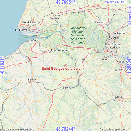
Saint-Georges-du-Vièvre GPS coordinates[2]
49° 14' 36.996" North, 0° 35' 5.676" East
| Map corner | latitude | longitude |
|---|---|---|
| Upper-left | 49.70051°, | -0.11821° |
| Center: | 49.24361°, | 0.58491° |
| Lower-right: | 48.78244°, | 1.28804° |
| Map W x H: | 102.1×102.1 km | = 63.4×63.4mi |
| max Lat: | 51.07786° ⇑14.9% North |
| Saint-Georges-du-Vièvre: | 49.24361° |
| min Lat: | ⇓85.1% South 41.3874° |
| min Long | Saint-Georges-d | max Long |
| -5.08615° | 0.58491° | 9.52242° |
| W 27.5%⇐ | ⇒72.5% E |
Elevation
Elevation of Saint-Georges-du-Vièvre is 141 m = 463 ft, and this is 52.7 m = 173 ft below average elevation for this country.
| Max E: |
2333 m = 7654 ft | 47.5% |
| Avg. | 193.7 m = 635 ft | |
| Saint-Georges-du-Vièvre | 141 m = 463 ft | |
Min E: |
-1 m = -3 ft | 52.5% |
See also: France elevation on elevation.city.
Geographical zone
Saint-Georges-du-Vièvre is located in North temperate zone (between Tropic of Cancer and the Arctic Circle). Distance of this North polar circle is 1925.8 km =1196.6 mi to North.| Distance of | km | miles | from Saint-Georges-du-Vièvre |
|---|---|---|---|
| North Pole | 4531.7 | 2815.9 | to North |
| Arctic Circle | 1925.8 | 1196.6 | to North |
| Tropic Cancer | 2869.5 | 1783 | to South |
| Equator | 5475.4 | 3402.3 | to South |


Nearby cities:
15 places around Saint-Georges-du-Vièvre: (largest is in red/bold)
• Appeville-Annebault
8.7 km =5.4 mi,  31°
31°
• Brionne
10.9 km =6.8 mi,  119°
119°
• Campigny
7.7 km =4.8 mi,  343°
343°
• Corneville-sur-Risle
10.9 km =6.8 mi,  0°
0°
• Courbépine
13.1 km =8.1 mi,  187°
187°
• Lieurey
6.4 km =4 mi,  256°
256°
• Manneville-sur-Risle
12.4 km =7.7 mi,  346°
346°
• Montfort-sur-Risle
8.1 km =5 mi,  44°
44°
• Plasnes
12.3 km =7.6 mi,  166°
166°
• Pont-Audemer
12.8 km =8 mi, 337°
• Pont-Authou
9.3 km =5.8 mi,  89°
89°
• Saint-Germain-Village
13.1 km =8.1 mi,  333°
333°
• Saint-Philbert-sur-Risle
7.5 km =4.7 mi, 38°
• Tourville-sur-Pont-Audemer
10.6 km =6.6 mi, 331°
• Épaignes
11.3 km =7 mi,  290°
290°
Sources, notices
• [Note1] Compared only with cities in France existing in our database
• [Src1] Map data: © OpenStreetMap contributors (CC-BY-SA)
• [Src2] Other city data from geonames.org with taken over terms of usage.
• [Src3] Geographical zone / Annual Mean Temperature by Robert A. Rohde @ Wikipedia
