Saint-Ours geodata
Saint-Ours (Auvergne-Rhône-Alpes) is a populated place; located in France in Europe/Paris (GMT+2) time zone. With population of 502 people, there are 15200 cities with bigger population in this country. Compared to other cities in France, 69.9% of cities are located further ↑North; 86.9% of cities are located further ←West and 94.7% of cities have lower elevation than Saint-Ours. Note1
Administrative division(s):
- Level 1: Auvergne-Rhône-Alpes
- Level 2: Savoie
- Level 3: Arrondissement de Chambéry
- Level 4: Saint-Ours


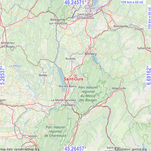
Saint-Ours GPS coordinates[2]
45° 45' 26.28" North, 5° 59' 18.6" East
| Map corner | latitude | longitude |
|---|---|---|
| Upper-left | 46.24571°, | 5.28537° |
| Center: | 45.7573°, | 5.9885° |
| Lower-right: | 45.26457°, | 6.69162° |
| Map W x H: | 109.1×109.1 km | = 67.8×67.8mi |
| max Lat: | 51.07786° ⇑69.9% North |
| Saint-Ours: | 45.7573° |
| min Lat: | ⇓30.1% South 41.3874° |
| min Long | Saint-Ours | max Long |
| -5.08615° | 5.9885° | 9.52242° |
| W 86.9%⇐ | ⇒13.1% E |
Elevation
Elevation of Saint-Ours is 569 m = 1867 ft, and this is 375.3 m = 1231 ft above average elevation for this country.
| Max E: |
2333 m = 7654 ft | 5.3% |
| Saint-Ours | 569 m 1867 ft | |
| Avg. | 193.7 m = 635 ft | |
Min E: |
-1 m = -3 ft | 94.7% |
See also: France elevation on elevation.city.
Geographical zone
Saint-Ours is located in North temperate zone (between Tropic of Cancer and the Arctic Circle). Distance of this North polar circle is 2313.4 km =1437.5 mi to North.| Distance of | km | miles | from Saint-Ours |
|---|---|---|---|
| North Pole | 4919.3 | 3056.7 | to North |
| Arctic Circle | 2313.4 | 1437.5 | to North |
| Tropic Cancer | 2481.8 | 1542.1 | to South |
| Equator | 5087.7 | 3161.3 | to South |


Nearby cities:
15 places around Saint-Ours: (largest is in red/bold)
• Albens
4.8 km =3 mi,  315°
315°
• Alby-sur-Chéran
7 km =4.3 mi,  18°
18°
• Chainaz-les-Frasses
1.9 km =1.2 mi, 18°
• Cusy
3.2 km =2 mi,  72°
72°
• Gruffy
6.3 km =3.9 mi,  56°
56°
• Grésy-sur-Aix
6.2 km =3.9 mi,  232°
232°
• Héry-sur-Alby
4.7 km =2.9 mi, 21°
• La Biolle
4.6 km =2.9 mi,  271°
271°
• Marigny-Saint-Marcel
8.2 km =5.1 mi,  355°
355°
• Montcel
3.6 km =2.2 mi,  186°
186°
• Mûres
6.6 km =4.1 mi,  35°
35°
• Pugny-Chatenod
7.2 km =4.5 mi,  205°
205°
• Saint-Félix
5.1 km =3.2 mi,  350°
350°
• Saint-Offenge-dessous
2.8 km =1.7 mi,  155°
155°
• Trévignin
6.3 km =3.9 mi,  204°
204°
Sources, notices
• [Note1] Compared only with cities in France existing in our database
• [Src1] Map data: © OpenStreetMap contributors (CC-BY-SA)
• [Src2] Other city data from geonames.org with taken over terms of usage.
• [Src3] Geographical zone / Annual Mean Temperature by Robert A. Rohde @ Wikipedia
