Saint-Martory geodata
Saint-Martory (Occitanie) is a populated place; located in France in Europe/Paris (GMT+2) time zone. With population of 989 people, there are 8914 cities with bigger population in this country. Compared to other cities in France, 97.6% of cities are located further ↑North; 69.4% of cities are located further →East and 80% of cities have lower elevation than Saint-Martory. Note1
Administrative division(s):
- Level 1: Occitanie
- Level 2: Haute-Garonne
- Level 3: Arrondissement de Saint-Gaudens
- Level 4: Saint-Martory


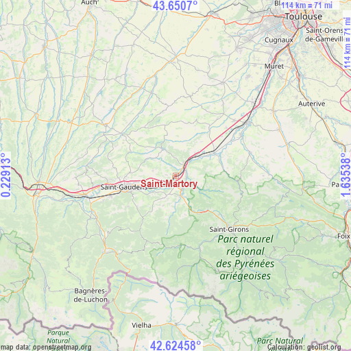
Saint-Martory GPS coordinates[2]
43° 8' 23.244" North, 0° 55' 56.1" East
| Map corner | latitude | longitude |
|---|---|---|
| Upper-left | 43.6507°, | 0.22913° |
| Center: | 43.13979°, | 0.93225° |
| Lower-right: | 42.62458°, | 1.63538° |
| Map W x H: | 114.1×114.1 km | = 70.9×70.9mi |
| max Lat: | 51.07786° ⇑97.6% North |
| Saint-Martory: | 43.13979° |
| min Lat: | ⇓2.4% South 41.3874° |
| min Long | Saint-Martory | max Long |
| -5.08615° | 0.93225° | 9.52242° |
| W 30.6%⇐ | ⇒69.4% E |
Elevation
Elevation of Saint-Martory is 290 m = 951 ft, and this is 96.3 m = 316 ft above average elevation for this country.
| Max E: |
2333 m = 7654 ft | 20% |
| Saint-Martory | 290 m 951 ft | |
| Avg. | 193.7 m = 635 ft | |
Min E: |
-1 m = -3 ft | 80% |
See also: France elevation on elevation.city.
Geographical zone
Saint-Martory is located in North temperate zone (between Tropic of Cancer and the Arctic Circle). Distance of this Northern Tropic circle is 2190.8 km =1361.3 mi to South.| Distance of | km | miles | from Saint-Martory |
|---|---|---|---|
| North Pole | 5210.4 | 3237.6 | to North |
| Arctic Circle | 2604.5 | 1618.4 | to North |
| Tropic Cancer | 2190.8 | 1361.3 | to South |
| Equator | 4796.7 | 2980.5 | to South |


Nearby cities:
15 places around Saint-Martory: (largest is in red/bold)
• Aurignac
9.5 km =5.9 mi,  334°
334°
• Boussens
5.2 km =3.2 mi,  38°
38°
• Cassagne
5.1 km =3.2 mi,  113°
113°
• Cazères
14.6 km =9.1 mi,  59°
59°
• Estancarbon
12.5 km =7.8 mi,  251°
251°
• Labarthe-Inard
8.6 km =5.3 mi, 245°
• Landorthe
11.9 km =7.4 mi,  265°
265°
• Mane
6.6 km =4.1 mi,  165°
165°
• Martres-Tolosane
9.2 km =5.7 mi, 43°
• Mondavezan
13.9 km =8.6 mi, 37°
• Palaminy
13 km =8.1 mi, 57°
• Pointis-Inard
11.4 km =7.1 mi,  238°
238°
• Prat-Bonrepaux
13.7 km =8.5 mi,  149°
149°
• Roquefort-sur-Garonne
4.2 km =2.6 mi,  53°
53°
• Salies-du-Salat
4.8 km =3 mi, 153°
Sources, notices
• [Note1] Compared only with cities in France existing in our database
• [Src1] Map data: © OpenStreetMap contributors (CC-BY-SA)
• [Src2] Other city data from geonames.org with taken over terms of usage.
• [Src3] Geographical zone / Annual Mean Temperature by Robert A. Rohde @ Wikipedia
