Martres-Tolosane geodata
Martres-Tolosane (Occitanie) is a populated place; located in France in Europe/Paris (GMT+2) time zone. With population of 1,927 people, there are 4969 cities with bigger population in this country. Compared to other cities in France, 97.1% of cities are located further ↑North; 68.7% of cities are located further →East and 78.1% of cities have lower elevation than Martres-Tolosane. Note1
Administrative division(s):
- Level 1: Occitanie
- Level 2: Haute-Garonne
- Level 3: Arrondissement de Muret
- Level 4: Martres-Tolosane


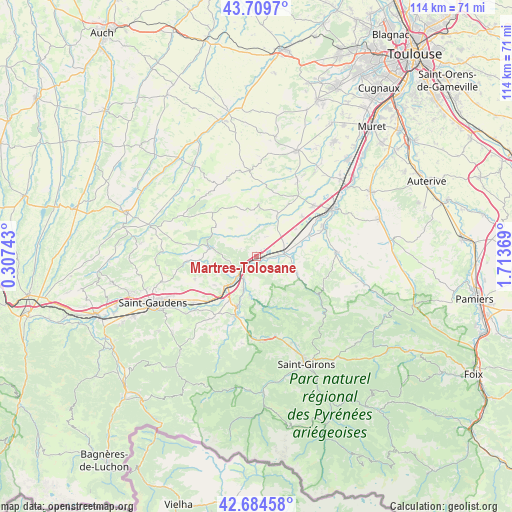
Martres-Tolosane GPS coordinates[2]
43° 11' 57.444" North, 1° 0' 38.016" East
| Map corner | latitude | longitude |
|---|---|---|
| Upper-left | 43.7097°, | 0.30743° |
| Center: | 43.19929°, | 1.01056° |
| Lower-right: | 42.68458°, | 1.71369° |
| Map W x H: | 114×114 km | = 70.8×70.8mi |
| max Lat: | 51.07786° ⇑97.1% North |
| Martres-Tolosane: | 43.19929° |
| min Lat: | ⇓2.9% South 41.3874° |
| min Long | Martres-Tolosan | max Long |
| -5.08615° | 1.01056° | 9.52242° |
| W 31.3%⇐ | ⇒68.7% E |
Elevation
Elevation of Martres-Tolosane is 273 m = 896 ft, and this is 79.3 m = 260 ft above average elevation for this country.
| Max E: |
2333 m = 7654 ft | 21.9% |
| Martres-Tolosane | 273 m 896 ft | |
| Avg. | 193.7 m = 635 ft | |
Min E: |
-1 m = -3 ft | 78.1% |
See also: France elevation on elevation.city.
Geographical zone
Martres-Tolosane is located in North temperate zone (between Tropic of Cancer and the Arctic Circle). Distance of this Northern Tropic circle is 2197.4 km =1365.4 mi to South.| Distance of | km | miles | from Martres-Tolosane |
|---|---|---|---|
| North Pole | 5203.8 | 3233.5 | to North |
| Arctic Circle | 2597.9 | 1614.3 | to North |
| Tropic Cancer | 2197.4 | 1365.4 | to South |
| Equator | 4803.3 | 2984.6 | to South |


Nearby cities:
15 places around Martres-Tolosane: (largest is in red/bold)
• Aurignac
10.6 km =6.6 mi,  280°
280°
• Boussens
4.1 km =2.5 mi,  230°
230°
• Cassagne
8.8 km =5.5 mi,  190°
190°
• Cazères
6.2 km =3.9 mi,  81°
81°
• Lavelanet-de-Comminges
10.6 km =6.6 mi,  54°
54°
• Le Fousseret
10.2 km =6.3 mi,  26°
26°
• Mane
13.9 km =8.6 mi,  199°
199°
• Mondavezan
4.9 km =3 mi, 25°
• Palaminy
4.6 km =2.9 mi,  85°
85°
• Rieux-Volvestre
16.4 km =10.2 mi,  69°
69°
• Roquefort-sur-Garonne
5.1 km =3.2 mi,  215°
215°
• Saint-Martory
9.2 km =5.7 mi, 223°
• Saint-Élix-le-Château
13.6 km =8.5 mi, 48°
• Sainte-Croix-Volvestre
14.6 km =9.1 mi,  120°
120°
• Salies-du-Salat
11.7 km =7.3 mi, 201°
Sources, notices
• [Note1] Compared only with cities in France existing in our database
• [Src1] Map data: © OpenStreetMap contributors (CC-BY-SA)
• [Src2] Other city data from geonames.org with taken over terms of usage.
• [Src3] Geographical zone / Annual Mean Temperature by Robert A. Rohde @ Wikipedia
