Saint-Loup-Géanges geodata
Saint-Loup-Géanges (Bourgogne-Franche-Comté) is a populated place; located in France in Europe/Paris (GMT+2) time zone. With population of 766 people, there are 10996 cities with bigger population in this country. Compared to other cities in France, 55.8% of cities are located further ↑North; 76.5% of cities are located further ←West and 62.7% of cities have lower elevation than Saint-Loup-Géanges. Note1
Administrative division(s):
- Level 1: Bourgogne-Franche-Comté
- Level 2: Département de Saône-et-Loire
- Level 3: Arrondissement de Chalon-sur-Saône
- Level 4: Saint-Loup-Géanges


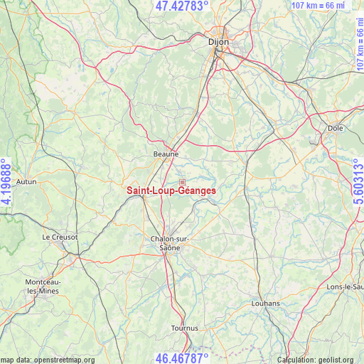
Saint-Loup-Géanges GPS coordinates[2]
46° 57' 0" North, 4° 54' 0" East
| Map corner | latitude | longitude |
|---|---|---|
| Upper-left | 47.42783°, | 4.19688° |
| Center: | 46.95°, | 4.9° |
| Lower-right: | 46.46787°, | 5.60313° |
| Map W x H: | 106.7×106.7 km | = 66.3×66.3mi |
| max Lat: | 51.07786° ⇑55.8% North |
| Saint-Loup-Géanges: | 46.95° |
| min Lat: | ⇓44.2% South 41.3874° |
| min Long | Saint-Loup-Géa | max Long |
| -5.08615° | 4.9° | 9.52242° |
| W 76.5%⇐ | ⇒23.5% E |
Elevation
Elevation of Saint-Loup-Géanges is 183 m = 600 ft, and this is 10.7 m = 35 ft below average elevation for this country.
| Max E: |
2333 m = 7654 ft | 37.3% |
| Avg. | 193.7 m = 635 ft | |
| Saint-Loup-Géanges | 183 m = 600 ft | |
Min E: |
-1 m = -3 ft | 62.7% |
See also: France elevation on elevation.city.
Geographical zone
Saint-Loup-Géanges is located in North temperate zone (between Tropic of Cancer and the Arctic Circle). Distance of this North polar circle is 2180.8 km =1355.1 mi to North.| Distance of | km | miles | from Saint-Loup-Géanges |
|---|---|---|---|
| North Pole | 4786.7 | 2974.3 | to North |
| Arctic Circle | 2180.8 | 1355.1 | to North |
| Tropic Cancer | 2614.4 | 1624.5 | to South |
| Equator | 5220.4 | 3243.8 | to South |


Nearby cities:
15 places around Saint-Loup-Géanges: (largest is in red/bold)
• Allerey-sur-Saône
8 km =5 mi,  128°
128°
• Beaune
9.5 km =5.9 mi,  330°
330°
• Bligny-lès-Beaune
6.9 km =4.3 mi,  305°
305°
• Chaudenay
9.4 km =5.8 mi,  246°
246°
• Demigny
5.5 km =3.4 mi, 246°
• Gergy
9 km =5.6 mi,  157°
157°
• Lessard-le-National
10.4 km =6.5 mi,  206°
206°
• Merceuil
4.4 km =2.7 mi,  269°
269°
• Meursault
10.4 km =6.5 mi,  287°
287°
• Montagny-lès-Beaune
6 km =3.7 mi,  320°
320°
• Pommard
10.4 km =6.5 mi, 309°
• Ruffey-lès-Beaune
7.7 km =4.8 mi,  7°
7°
• Sainte-Marie-la-Blanche
3.2 km =2 mi,  346°
346°
• Verjux
9.3 km =5.8 mi,  148°
148°
• Vignoles
8.9 km =5.5 mi, 353°
Sources, notices
• [Note1] Compared only with cities in France existing in our database
• [Src1] Map data: © OpenStreetMap contributors (CC-BY-SA)
• [Src2] Other city data from geonames.org with taken over terms of usage.
• [Src3] Geographical zone / Annual Mean Temperature by Robert A. Rohde @ Wikipedia
