Lessard-le-National geodata
Lessard-le-National (Bourgogne-Franche-Comté) is a populated place; located in France in Europe/Paris (GMT+2) time zone. With population of 560 people, there are 14001 cities with bigger population in this country. Compared to other cities in France, 56.5% of cities are located further ↑North; 75.6% of cities are located further ←West and 66.2% of cities have lower elevation than Lessard-le-National. Note1
Administrative division(s):
- Level 1: Bourgogne-Franche-Comté
- Level 2: Département de Saône-et-Loire
- Level 3: Arrondissement de Chalon-sur-Saône
- Level 4: Lessard-le-National


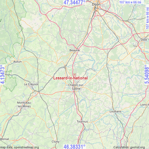
Lessard-le-National GPS coordinates[2]
46° 51' 58.284" North, 4° 50' 16.26" East
| Map corner | latitude | longitude |
|---|---|---|
| Upper-left | 47.34477°, | 4.13473° |
| Center: | 46.86619°, | 4.83785° |
| Lower-right: | 46.38331°, | 5.54098° |
| Map W x H: | 106.9×106.9 km | = 66.4×66.4mi |
| max Lat: | 51.07786° ⇑56.5% North |
| Lessard-le-National: | 46.86619° |
| min Lat: | ⇓43.5% South 41.3874° |
| min Long | Lessard-le-Nati | max Long |
| -5.08615° | 4.83785° | 9.52242° |
| W 75.6%⇐ | ⇒24.4% E |
Elevation
Elevation of Lessard-le-National is 200 m = 656 ft, and this is 6.3 m = 21 ft above average elevation for this country.
| Max E: |
2333 m = 7654 ft | 33.8% |
| Lessard-le-National | 200 m 656 ft | |
| Avg. | 193.7 m = 635 ft | |
Min E: |
-1 m = -3 ft | 66.2% |
See also: France elevation on elevation.city.
Geographical zone
Lessard-le-National is located in North temperate zone (between Tropic of Cancer and the Arctic Circle). Distance of this North polar circle is 2190.1 km =1360.9 mi to North.| Distance of | km | miles | from Lessard-le-National |
|---|---|---|---|
| North Pole | 4796 | 2980.1 | to North |
| Arctic Circle | 2190.1 | 1360.9 | to North |
| Tropic Cancer | 2605.1 | 1618.7 | to South |
| Equator | 5211 | 3238 | to South |


Nearby cities:
15 places around Lessard-le-National: (largest is in red/bold)
• Chagny
8.1 km =5 mi,  306°
306°
• Chalon-sur-Saône
9.5 km =5.9 mi,  172°
172°
• Champforgeuil
5.3 km =3.3 mi,  183°
183°
• Chaudenay
6.8 km =4.2 mi,  325°
325°
• Châtenoy-le-Royal
7.8 km =4.8 mi,  194°
194°
• Crissey
6.5 km =4 mi,  148°
148°
• Demigny
7.2 km =4.5 mi,  357°
357°
• Farges-lès-Chalon
4.2 km =2.6 mi,  212°
212°
• Fontaines
5.5 km =3.4 mi,  249°
249°
• Fragnes
3.4 km =2.1 mi, 171°
• Gergy
8.2 km =5.1 mi,  82°
82°
• Merceuil
9.3 km =5.8 mi,  2°
2°
• Rully
7.3 km =4.5 mi,  277°
277°
• Sassenay
7.7 km =4.8 mi,  120°
120°
• Virey-le-Grand
4.3 km =2.7 mi, 149°
Sources, notices
• [Note1] Compared only with cities in France existing in our database
• [Src1] Map data: © OpenStreetMap contributors (CC-BY-SA)
• [Src2] Other city data from geonames.org with taken over terms of usage.
• [Src3] Geographical zone / Annual Mean Temperature by Robert A. Rohde @ Wikipedia
