Saint-Léger-les-Vignes geodata
Saint-Léger-les-Vignes (Pays de la Loire) is a populated place; located in France in Europe/Paris (GMT+2) time zone. With population of 1,245 people, there are 7310 cities with bigger population in this country. Compared to other cities in France, 53.8% of cities are located further ↑North; 93.7% of cities are located further →East and 97% of cities have higher elevation than Saint-Léger-les-Vignes. Note1
Administrative division(s):
- Level 1: Pays de la Loire
- Level 2: Loire-Atlantique
- Level 3: Arrondissement de Nantes
- Level 4: Saint-Léger-les-Vignes
Current local time in Saint-Léger-les-Vignes:
06:31 PM, SaturdayDifference from your time zone: hours


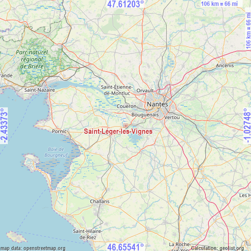
Saint-Léger-les-Vignes GPS coordinates[2]
47° 8' 9.132" North, 1° 43' 50.16" West
| Map corner | latitude | longitude |
|---|---|---|
| Upper-left | 47.61203°, | -2.43373° |
| Center: | 47.13587°, | -1.7306° |
| Lower-right: | 46.65541°, | -1.02748° |
| Map W x H: | 106.4×106.4 km | = 66.1×66.1mi |
| max Lat: | 51.07786° ⇑53.8% North |
| Saint-Léger-les-Vignes: | 47.13587° |
| min Lat: | ⇓46.2% South 41.3874° |
| min Long | Saint-Léger-le | max Long |
| -5.08615° | -1.7306° | 9.52242° |
| W 6.3%⇐ | ⇒93.7% E |
Elevation
Elevation of Saint-Léger-les-Vignes is 11 m = 36 ft, and this is 182.7 m = 599 ft below average elevation for this country.
| Max E: |
2333 m = 7654 ft | 97% |
| Avg. | 193.7 m = 635 ft | |
| Saint-Léger-les-Vignes | 11 m = 36 ft | |
Min E: |
-1 m = -3 ft | 3% |
See also: France elevation on elevation.city.
Geographical zone
Saint-Léger-les-Vignes is located in North temperate zone (between Tropic of Cancer and the Arctic Circle). Distance of this North polar circle is 2160.2 km =1342.3 mi to North.| Distance of | km | miles | from Saint-Léger-les-Vignes |
|---|---|---|---|
| North Pole | 4766 | 2961.5 | to North |
| Arctic Circle | 2160.2 | 1342.3 | to North |
| Tropic Cancer | 2635.1 | 1637.4 | to South |
| Equator | 5241 | 3256.6 | to South |


Nearby cities:
15 places around Saint-Léger-les-Vignes: (largest is in red/bold)
• Bouaye
2.9 km =1.8 mi,  75°
75°
• Bouguenais
9.5 km =5.9 mi,  60°
60°
• Brains
3.7 km =2.3 mi,  9°
9°
• Cheix-en-Retz
8.1 km =5 mi,  308°
308°
• Couëron
8.8 km =5.5 mi,  4°
4°
• Indre
8.6 km =5.3 mi,  34°
34°
• La Chevrolière
10.4 km =6.5 mi,  118°
118°
• La Montagne
6.7 km =4.2 mi, 32°
• Le Pellerin
7.3 km =4.5 mi,  345°
345°
• Port-Saint-Père
1.4 km =0.9 mi,  256°
256°
• Saint-Herblain
11 km =6.8 mi, 34°
• Saint-Jean-de-Boiseau
6.4 km =4 mi, 4°
• Saint-Lumine-de-Coutais
9.1 km =5.7 mi,  178°
178°
• Saint-Mars-de-Coutais
2.7 km =1.7 mi,  186°
186°
• Sainte-Pazanne
7 km =4.3 mi,  238°
238°
Sources, notices
• [Note1] Compared only with cities in France existing in our database
• [Src1] Map data: © OpenStreetMap contributors (CC-BY-SA)
• [Src2] Other city data from geonames.org with taken over terms of usage.
• [Src3] Geographical zone / Annual Mean Temperature by Robert A. Rohde @ Wikipedia
