Saint-Jean-de-Boiseau geodata
Saint-Jean-de-Boiseau (Pays de la Loire) is a populated place; located in France in Europe/Paris (GMT+2) time zone. With population of 4,906 people, there are 2019 cities with bigger population in this country. Compared to other cities in France, 53.1% of cities are located further ↑North; 93.6% of cities are located further →East and 92.7% of cities have higher elevation than Saint-Jean-de-Boiseau. Note1
Administrative division(s):
- Level 1: Pays de la Loire
- Level 2: Loire-Atlantique
- Level 3: Arrondissement de Nantes
- Level 4: Saint-Jean-de-Boiseau
Current local time in Saint-Jean-de-Boiseau:
09:00 PM, SaturdayDifference from your time zone: hours


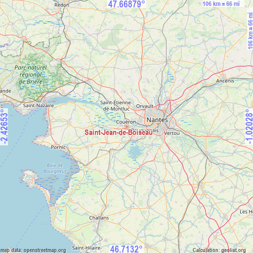
Saint-Jean-de-Boiseau GPS coordinates[2]
47° 11' 35.34" North, 1° 43' 24.24" West
| Map corner | latitude | longitude |
|---|---|---|
| Upper-left | 47.66879°, | -2.42653° |
| Center: | 47.19315°, | -1.7234° |
| Lower-right: | 46.7132°, | -1.02028° |
| Map W x H: | 106.3×106.2 km | = 66.1×66mi |
| max Lat: | 51.07786° ⇑53.1% North |
| Saint-Jean-de-Boiseau: | 47.19315° |
| min Lat: | ⇓46.9% South 41.3874° |
| min Long | Saint-Jean-de-B | max Long |
| -5.08615° | -1.7234° | 9.52242° |
| W 6.4%⇐ | ⇒93.6% E |
Elevation
Elevation of Saint-Jean-de-Boiseau is 23 m = 75 ft, and this is 170.7 m = 560 ft below average elevation for this country.
| Max E: |
2333 m = 7654 ft | 92.7% |
| Avg. | 193.7 m = 635 ft | |
| Saint-Jean-de-Boiseau | 23 m = 75 ft | |
Min E: |
-1 m = -3 ft | 7.3% |
See also: France elevation on elevation.city.
Geographical zone
Saint-Jean-de-Boiseau is located in North temperate zone (between Tropic of Cancer and the Arctic Circle). Distance of this North polar circle is 2153.8 km =1338.3 mi to North.| Distance of | km | miles | from Saint-Jean-de-Boiseau |
|---|---|---|---|
| North Pole | 4759.7 | 2957.5 | to North |
| Arctic Circle | 2153.8 | 1338.3 | to North |
| Tropic Cancer | 2641.5 | 1641.4 | to South |
| Equator | 5247.4 | 3260.6 | to South |


Nearby cities:
15 places around Saint-Jean-de-Boiseau: (largest is in red/bold)
• Bouaye
6.1 km =3.8 mi,  157°
157°
• Bouguenais
7.9 km =4.9 mi,  102°
102°
• Brains
2.7 km =1.7 mi,  179°
179°
• Cheix-en-Retz
7 km =4.3 mi,  259°
259°
• Couëron
2.4 km =1.5 mi,  2°
2°
• Indre
4.4 km =2.7 mi,  79°
79°
• La Montagne
3.2 km =2 mi, 103°
• Le Pellerin
2.5 km =1.6 mi,  285°
285°
• Port-Saint-Père
7 km =4.3 mi,  195°
195°
• Rouans
10.3 km =6.4 mi, 263°
• Saint-Herblain
6.3 km =3.9 mi,  64°
64°
• Saint-Léger-les-Vignes
6.4 km =4 mi, 184°
• Saint-Mars-de-Coutais
9.1 km =5.7 mi,  185°
185°
• Saint-Étienne-de-Montluc
10.3 km =6.4 mi,  335°
335°
• Sautron
8.7 km =5.4 mi,  27°
27°
Sources, notices
• [Note1] Compared only with cities in France existing in our database
• [Src1] Map data: © OpenStreetMap contributors (CC-BY-SA)
• [Src2] Other city data from geonames.org with taken over terms of usage.
• [Src3] Geographical zone / Annual Mean Temperature by Robert A. Rohde @ Wikipedia
