Indre geodata
Indre (Pays de la Loire) is a populated place; located in France in Europe/Paris (GMT+2) time zone. With population of 3,897 people, there are 2520 cities with bigger population in this country. Compared to other cities in France, 53% of cities are located further ↑North; 93.3% of cities are located further →East and 99.6% of cities have higher elevation than Indre. Note1
Administrative division(s):
- Level 1: Pays de la Loire
- Level 2: Loire-Atlantique
- Level 3: Arrondissement de Nantes
- Level 4: Indre


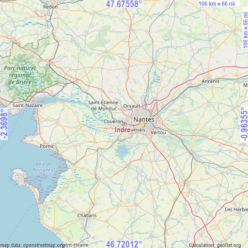
Indre GPS coordinates[2]
47° 12' 0" North, 1° 40' 0.012" West
| Map corner | latitude | longitude |
|---|---|---|
| Upper-left | 47.67558°, | -2.3698° |
| Center: | 47.2°, | -1.66667° |
| Lower-right: | 46.72012°, | -0.96355° |
| Map W x H: | 106.2×106.2 km | = 66×66mi |
| max Lat: | 51.07786° ⇑53% North |
| Indre: | 47.2° |
| min Lat: | ⇓47% South 41.3874° |
| min Long | Indre | max Long |
| -5.08615° | -1.66667° | 9.52242° |
| W 6.7%⇐ | ⇒93.3% E |
Elevation
Elevation of Indre is 4 m = 13 ft, and this is 189.7 m = 622 ft below average elevation for this country.
| Max E: |
2333 m = 7654 ft | 99.6% |
| Avg. | 193.7 m = 635 ft | |
| Indre | 4 m = 13 ft | |
Min E: |
-1 m = -3 ft | 0.4% |
See also: France elevation on elevation.city.
Geographical zone
Indre is located in North temperate zone (between Tropic of Cancer and the Arctic Circle). Distance of this North polar circle is 2153 km =1337.8 mi to North.| Distance of | km | miles | from Indre |
|---|---|---|---|
| North Pole | 4758.9 | 2957 | to North |
| Arctic Circle | 2153 | 1337.8 | to North |
| Tropic Cancer | 2642.2 | 1641.8 | to South |
| Equator | 5248.1 | 3261 | to South |


Nearby cities:
15 places around Indre: (largest is in red/bold)
• Bouaye
6.7 km =4.2 mi,  197°
197°
• Bouguenais
4.2 km =2.6 mi,  126°
126°
• Brains
5.5 km =3.4 mi,  230°
230°
• Couëron
4.5 km =2.8 mi,  291°
291°
• La Montagne
1.9 km =1.2 mi,  218°
218°
• Le Pellerin
6.7 km =4.2 mi,  269°
269°
• Nantes
8.8 km =5.5 mi,  77°
77°
• Orvault
8.6 km =5.3 mi,  23°
23°
• Pont-Saint-Martin
10.5 km =6.5 mi,  143°
143°
• Port-Saint-Père
9.7 km =6 mi, 219°
• Rezé
9.1 km =5.7 mi,  103°
103°
• Saint-Herblain
2.4 km =1.5 mi,  35°
35°
• Saint-Jean-de-Boiseau
4.4 km =2.7 mi,  259°
259°
• Saint-Léger-les-Vignes
8.6 km =5.3 mi,  214°
214°
• Sautron
7 km =4.3 mi,  357°
357°
Sources, notices
• [Note1] Compared only with cities in France existing in our database
• [Src1] Map data: © OpenStreetMap contributors (CC-BY-SA)
• [Src2] Other city data from geonames.org with taken over terms of usage.
• [Src3] Geographical zone / Annual Mean Temperature by Robert A. Rohde @ Wikipedia
