Saint-Laurent-sur-Manoire geodata
Saint-Laurent-sur-Manoire (Nouvelle-Aquitaine) is a populated place; located in France in Europe/Paris (GMT+2) time zone. With population of 805 people, there are 10549 cities with bigger population in this country. Compared to other cities in France, 78% of cities are located further ↑North; 70.6% of cities are located further →East and 56.5% of cities have higher elevation than Saint-Laurent-sur-Manoire. Note1
Administrative division(s):
- Level 1: Nouvelle-Aquitaine
- Level 2: Dordogne
- Level 3: Arrondissement de Périgueux
- Level 4: Boulazac Isle Manoire
Current local time in Saint-Laurent-sur-Manoire:
12:38 PM, SaturdayDifference from your time zone: hours


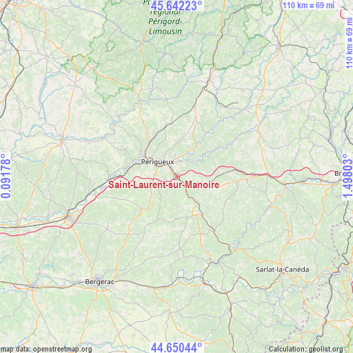
Saint-Laurent-sur-Manoire GPS coordinates[2]
45° 8' 54.564" North, 0° 47' 41.64" East
| Map corner | latitude | longitude |
|---|---|---|
| Upper-left | 45.64223°, | 0.09178° |
| Center: | 45.14849°, | 0.7949° |
| Lower-right: | 44.65044°, | 1.49803° |
| Map W x H: | 110.3×110.3 km | = 68.5×68.5mi |
| max Lat: | 51.07786° ⇑78% North |
| Saint-Laurent-sur-Manoire: | 45.14849° |
| min Lat: | ⇓22% South 41.3874° |
| min Long | Saint-Laurent-s | max Long |
| -5.08615° | 0.7949° | 9.52242° |
| W 29.4%⇐ | ⇒70.6% E |
Elevation
Elevation of Saint-Laurent-sur-Manoire is 112 m = 367 ft, and this is 81.7 m = 268 ft below average elevation for this country.
| Max E: |
2333 m = 7654 ft | 56.5% |
| Avg. | 193.7 m = 635 ft | |
| Saint-Laurent-sur-Manoire | 112 m = 367 ft | |
Min E: |
-1 m = -3 ft | 43.5% |
See also: France elevation on elevation.city.
Geographical zone
Saint-Laurent-sur-Manoire is located in North temperate zone (between Tropic of Cancer and the Arctic Circle). Distance of this North polar circle is 2381.1 km =1479.5 mi to North.| Distance of | km | miles | from Saint-Laurent-sur-Manoire |
|---|---|---|---|
| North Pole | 4987 | 3098.8 | to North |
| Arctic Circle | 2381.1 | 1479.5 | to North |
| Tropic Cancer | 2414.1 | 1500.1 | to South |
| Equator | 5020 | 3119.3 | to South |


Nearby cities:
15 places around Saint-Laurent-sur-Manoire: (largest is in red/bold)
• Antonne-et-Trigonant
7.7 km =4.8 mi,  21°
21°
• Atur
3.9 km =2.4 mi,  257°
257°
• Bassillac
5.2 km =3.2 mi, 17°
• Boulazac
5 km =3.1 mi,  224°
224°
• Champcevinel
9.2 km =5.7 mi,  325°
325°
• Chancelade
11.2 km =7 mi,  301°
301°
• Coulounieix-Chamiers
8.4 km =5.2 mi,  273°
273°
• Eyliac
5 km =3.1 mi,  72°
72°
• La Douze
11 km =6.8 mi,  150°
150°
• Le Change
9.5 km =5.9 mi,  55°
55°
• Marsaneix
5.6 km =3.5 mi,  188°
188°
• Notre-Dame-de-Sanilhac
7.2 km =4.5 mi,  245°
245°
• Périgueux
7.3 km =4.5 mi, 302°
• Saint-Pierre-de-Chignac
5.5 km =3.4 mi,  119°
119°
• Trélissac
5.5 km =3.4 mi,  352°
352°
Sources, notices
• [Note1] Compared only with cities in France existing in our database
• [Src1] Map data: © OpenStreetMap contributors (CC-BY-SA)
• [Src2] Other city data from geonames.org with taken over terms of usage.
• [Src3] Geographical zone / Annual Mean Temperature by Robert A. Rohde @ Wikipedia
