Antonne-et-Trigonant geodata
Antonne-et-Trigonant (Nouvelle-Aquitaine) is a populated place; located in France in Europe/Paris (GMT+2) time zone. With population of 1,150 people, there are 7821 cities with bigger population in this country. Compared to other cities in France, 77.3% of cities are located further ↑North; 70.3% of cities are located further →East and 57.6% of cities have higher elevation than Antonne-et-Trigonant. Note1
Administrative division(s):
- Level 1: Nouvelle-Aquitaine
- Level 2: Dordogne
- Level 3: Arrondissement de Périgueux
- Level 4: Antonne-et-Trigonant


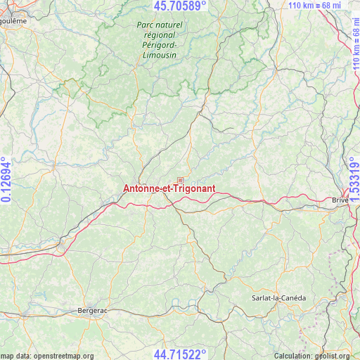
Antonne-et-Trigonant GPS coordinates[2]
45° 12' 45.756" North, 0° 49' 48.216" East
| Map corner | latitude | longitude |
|---|---|---|
| Upper-left | 45.70589°, | 0.12694° |
| Center: | 45.21271°, | 0.83006° |
| Lower-right: | 44.71522°, | 1.53319° |
| Map W x H: | 110.2×110.2 km | = 68.5×68.5mi |
| max Lat: | 51.07786° ⇑77.3% North |
| Antonne-et-Trigonant: | 45.21271° |
| min Lat: | ⇓22.7% South 41.3874° |
| min Long | Antonne-et-Trig | max Long |
| -5.08615° | 0.83006° | 9.52242° |
| W 29.7%⇐ | ⇒70.3% E |
Elevation
Elevation of Antonne-et-Trigonant is 109 m = 358 ft, and this is 84.7 m = 278 ft below average elevation for this country.
| Max E: |
2333 m = 7654 ft | 57.6% |
| Avg. | 193.7 m = 635 ft | |
| Antonne-et-Trigonant | 109 m = 358 ft | |
Min E: |
-1 m = -3 ft | 42.4% |
See also: France elevation on elevation.city.
Geographical zone
Antonne-et-Trigonant is located in North temperate zone (between Tropic of Cancer and the Arctic Circle). Distance of this North polar circle is 2374 km =1475.1 mi to North.| Distance of | km | miles | from Antonne-et-Trigonant |
|---|---|---|---|
| North Pole | 4979.9 | 3094.4 | to North |
| Arctic Circle | 2374 | 1475.1 | to North |
| Tropic Cancer | 2421.3 | 1504.5 | to South |
| Equator | 5027.2 | 3123.8 | to South |


Nearby cities:
15 places around Antonne-et-Trigonant: (largest is in red/bold)
• Agonac
10.8 km =6.7 mi,  324°
324°
• Atur
10.3 km =6.4 mi,  219°
219°
• Bassillac
2.5 km =1.6 mi,  207°
207°
• Boulazac
12.4 km =7.7 mi, 210°
• Champcevinel
8 km =5 mi,  272°
272°
• Cornille
5.6 km =3.5 mi, 319°
• Cubjac
8.6 km =5.3 mi,  82°
82°
• Eyliac
6 km =3.7 mi,  160°
160°
• Le Change
5.4 km =3.4 mi,  109°
109°
• Périgueux
9.5 km =5.9 mi,  249°
249°
• Saint-Laurent-sur-Manoire
7.7 km =4.8 mi,  201°
201°
• Saint-Pierre-de-Chignac
10.1 km =6.3 mi,  168°
168°
• Savignac-les-Églises
9.4 km =5.8 mi,  44°
44°
• Sorges
10.9 km =6.8 mi,  18°
18°
• Trélissac
3.8 km =2.4 mi,  244°
244°
Sources, notices
• [Note1] Compared only with cities in France existing in our database
• [Src1] Map data: © OpenStreetMap contributors (CC-BY-SA)
• [Src2] Other city data from geonames.org with taken over terms of usage.
• [Src3] Geographical zone / Annual Mean Temperature by Robert A. Rohde @ Wikipedia
