Périgueux geodata
Périgueux (Nouvelle-Aquitaine) is a seat of a second-order administrative division; located in France in Europe/Paris (GMT+2) time zone. With population of 34,770 people, there are 225 cities with bigger population in this country. Compared to other cities in France, 77.7% of cities are located further ↑North; 71.3% of cities are located further →East and 59.7% of cities have higher elevation than Périgueux. Note1
Administrative division(s):
- Level 1: Nouvelle-Aquitaine
- Level 2: Dordogne
- Level 3: Arrondissement de Périgueux
- Level 4: Périgueux


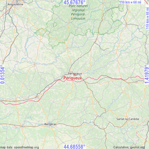
Périgueux GPS coordinates[2]
45° 10' 59.988" North, 0° 43' 0.012" East
| Map corner | latitude | longitude |
|---|---|---|
| Upper-left | 45.67676°, | 0.01354° |
| Center: | 45.18333°, | 0.71667° |
| Lower-right: | 44.68558°, | 1.41979° |
| Map W x H: | 110.2×110.2 km | = 68.5×68.5mi |
| max Lat: | 51.07786° ⇑77.7% North |
| Périgueux: | 45.18333° |
| min Lat: | ⇓22.3% South 41.3874° |
| min Long | Périgueux | max Long |
| -5.08615° | 0.71667° | 9.52242° |
| W 28.7%⇐ | ⇒71.3% E |
Elevation
Elevation of Périgueux is 103 m = 338 ft, and this is 90.7 m = 298 ft below average elevation for this country.
| Max E: |
2333 m = 7654 ft | 59.7% |
| Avg. | 193.7 m = 635 ft | |
| Périgueux | 103 m = 338 ft | |
Min E: |
-1 m = -3 ft | 40.3% |
See also: France elevation on elevation.city.
Geographical zone
Périgueux is located in North temperate zone (between Tropic of Cancer and the Arctic Circle). Distance of this North polar circle is 2377.3 km =1477.2 mi to North.| Distance of | km | miles | from Périgueux |
|---|---|---|---|
| North Pole | 4983.1 | 3096.4 | to North |
| Arctic Circle | 2377.3 | 1477.2 | to North |
| Tropic Cancer | 2418 | 1502.5 | to South |
| Equator | 5023.9 | 3121.7 | to South |


Nearby cities:
15 places around Périgueux: (largest is in red/bold)
• Antonne-et-Trigonant
9.5 km =5.9 mi,  69°
69°
• Atur
5.3 km =3.3 mi,  153°
153°
• Bassillac
7.8 km =4.8 mi,  82°
82°
• Boulazac
7.9 km =4.9 mi,  160°
160°
• Champcevinel
3.8 km =2.4 mi,  13°
13°
• Chancelade
3.9 km =2.4 mi,  298°
298°
• Cornille
9.2 km =5.7 mi,  34°
34°
• Coulounieix-Chamiers
4 km =2.5 mi,  213°
213°
• Coursac
8.6 km =5.3 mi,  225°
225°
• La Chapelle-Gonaguet
9.9 km =6.2 mi, 302°
• Marsaneix
10.8 km =6.7 mi, 150°
• Notre-Dame-de-Sanilhac
6.9 km =4.3 mi,  183°
183°
• Razac-sur-l’Isle
9.3 km =5.8 mi,  256°
256°
• Saint-Laurent-sur-Manoire
7.3 km =4.5 mi,  122°
122°
• Trélissac
5.7 km =3.5 mi, 73°
Sources, notices
• [Note1] Compared only with cities in France existing in our database
• [Src1] Map data: © OpenStreetMap contributors (CC-BY-SA)
• [Src2] Other city data from geonames.org with taken over terms of usage.
• [Src3] Geographical zone / Annual Mean Temperature by Robert A. Rohde @ Wikipedia
