Saint-Andéol-le-Château geodata
Saint-Andéol-le-Château (Auvergne-Rhône-Alpes) is a populated place; located in France in Europe/Paris (GMT+2) time zone. With population of 1,451 people, there are 6376 cities with bigger population in this country. Compared to other cities in France, 72.8% of cities are located further ↑North; 73.7% of cities are located further ←West and 82.2% of cities have lower elevation than Saint-Andéol-le-Château. Note1
Administrative division(s):
- Level 1: Auvergne-Rhône-Alpes
- Level 2: Département du Rhône
- Level 3: Arrondissement de Lyon
- Level 4: Beauvallon
Current local time in Saint-Andéol-le-Château:
03:46 PM, SaturdayDifference from your time zone: hours


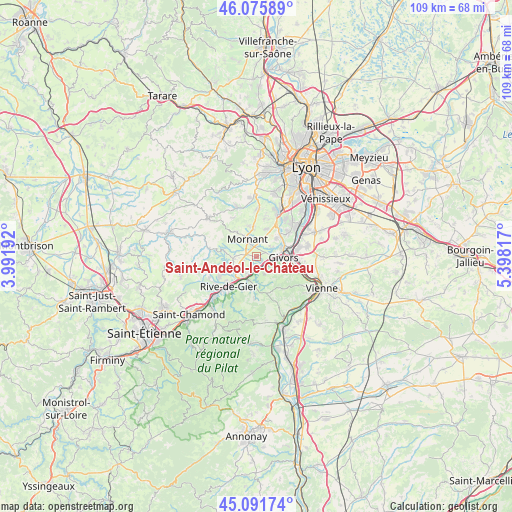
Saint-Andéol-le-Château GPS coordinates[2]
45° 35' 9.492" North, 4° 41' 42.144" East
| Map corner | latitude | longitude |
|---|---|---|
| Upper-left | 46.07589°, | 3.99192° |
| Center: | 45.58597°, | 4.69504° |
| Lower-right: | 45.09174°, | 5.39817° |
| Map W x H: | 109.4×109.4 km | = 68×68mi |
| max Lat: | 51.07786° ⇑72.8% North |
| Saint-Andéol-le-Château: | 45.58597° |
| min Lat: | ⇓27.2% South 41.3874° |
| min Long | Saint-Andéol-l | max Long |
| -5.08615° | 4.69504° | 9.52242° |
| W 73.7%⇐ | ⇒26.3% E |
Elevation
Elevation of Saint-Andéol-le-Château is 312 m = 1024 ft, and this is 118.3 m = 388 ft above average elevation for this country.
| Max E: |
2333 m = 7654 ft | 17.8% |
| Saint-Andéol-le-Château | 312 m 1024 ft | |
| Avg. | 193.7 m = 635 ft | |
Min E: |
-1 m = -3 ft | 82.2% |
See also: France elevation on elevation.city.
Geographical zone
Saint-Andéol-le-Château is located in North temperate zone (between Tropic of Cancer and the Arctic Circle). Distance of this North polar circle is 2332.5 km =1449.3 mi to North.| Distance of | km | miles | from Saint-Andéol-le-Château |
|---|---|---|---|
| North Pole | 4938.4 | 3068.6 | to North |
| Arctic Circle | 2332.5 | 1449.3 | to North |
| Tropic Cancer | 2462.8 | 1530.3 | to South |
| Equator | 5068.7 | 3149.5 | to South |


Nearby cities:
15 places around Saint-Andéol-le-Château: (largest is in red/bold)
• Chassagny
3.7 km =2.3 mi,  51°
51°
• Chaussan
6.8 km =4.2 mi,  320°
320°
• Givors
5.8 km =3.6 mi,  84°
84°
• Montagny
6.2 km =3.9 mi,  41°
41°
• Mornant
4.1 km =2.5 mi,  334°
334°
• Saint-Didier-sous-Riverie
7 km =4.3 mi,  279°
279°
• Saint-Jean-de-Touslas
2.9 km =1.8 mi,  250°
250°
• Saint-Joseph
6.6 km =4.1 mi,  241°
241°
• Saint-Maurice-sur-Dargoire
5 km =3.1 mi,  265°
265°
• Saint-Romain-en-Gier
2.5 km =1.6 mi,  158°
158°
• Saint-Sorlin
5.8 km =3.6 mi,  311°
311°
• Taluyers
6.3 km =3.9 mi,  19°
19°
• Tartaras
4.6 km =2.9 mi,  208°
208°
• Trèves
5.4 km =3.4 mi,  195°
195°
• Échalas
4.1 km =2.5 mi, 157°
Sources, notices
• [Note1] Compared only with cities in France existing in our database
• [Src1] Map data: © OpenStreetMap contributors (CC-BY-SA)
• [Src2] Other city data from geonames.org with taken over terms of usage.
• [Src3] Geographical zone / Annual Mean Temperature by Robert A. Rohde @ Wikipedia
