Sainte-Catherine geodata
Sainte-Catherine (Auvergne-Rhône-Alpes) is a populated place; located in France in Europe/Paris (GMT+2) time zone. With population of 916 people, there are 9519 cities with bigger population in this country. Compared to other cities in France, 72.6% of cities are located further ↑North; 72.5% of cities are located further ←West and 95.4% of cities have lower elevation than Sainte-Catherine. Note1
Administrative division(s):
- Level 1: Auvergne-Rhône-Alpes
- Level 2: Département du Rhône
- Level 3: Arrondissement de Lyon
- Level 4: Sainte-Catherine


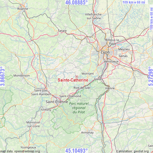
Sainte-Catherine GPS coordinates[2]
45° 35' 56.58" North, 4° 34' 11.46" East
| Map corner | latitude | longitude |
|---|---|---|
| Upper-left | 46.08885°, | 3.86673° |
| Center: | 45.59905°, | 4.56985° |
| Lower-right: | 45.10493°, | 5.27298° |
| Map W x H: | 109.4×109.4 km | = 68×68mi |
| max Lat: | 51.07786° ⇑72.6% North |
| Sainte-Catherine: | 45.59905° |
| min Lat: | ⇓27.4% South 41.3874° |
| min Long | Sainte-Catherin | max Long |
| -5.08615° | 4.56985° | 9.52242° |
| W 72.5%⇐ | ⇒27.5% E |
Elevation
Elevation of Sainte-Catherine is 609 m = 1998 ft, and this is 415.3 m = 1363 ft above average elevation for this country.
| Max E: |
2333 m = 7654 ft | 4.6% |
| Sainte-Catherine | 609 m 1998 ft | |
| Avg. | 193.7 m = 635 ft | |
Min E: |
-1 m = -3 ft | 95.4% |
See also: France elevation on elevation.city.
Geographical zone
Sainte-Catherine is located in North temperate zone (between Tropic of Cancer and the Arctic Circle). Distance of this North polar circle is 2331 km =1448.4 mi to North.| Distance of | km | miles | from Sainte-Catherine |
|---|---|---|---|
| North Pole | 4936.9 | 3067.6 | to North |
| Arctic Circle | 2331 | 1448.4 | to North |
| Tropic Cancer | 2464.2 | 1531.2 | to South |
| Equator | 5070.1 | 3150.4 | to South |


Nearby cities:
15 places around Sainte-Catherine: (largest is in red/bold)
• Chaussan
6.6 km =4.1 mi,  54°
54°
• Coise
7.7 km =4.8 mi,  282°
282°
• Larajasse
5.6 km =3.5 mi,  287°
287°
• Marcenod
7.4 km =4.6 mi,  245°
245°
• Mornant
8.3 km =5.2 mi,  74°
74°
• Rive-de-Gier
8.7 km =5.4 mi,  155°
155°
• Rontalon
8.4 km =5.2 mi,  35°
35°
• Saint-Didier-sous-Riverie
2.9 km =1.8 mi,  96°
96°
• Saint-Jean-de-Touslas
7.4 km =4.6 mi,  109°
109°
• Saint-Joseph
6.1 km =3.8 mi,  139°
139°
• Saint-Martin-en-Haut
6.8 km =4.2 mi,  354°
354°
• Saint-Martin-la-Plaine
6.2 km =3.9 mi, 159°
• Saint-Maurice-sur-Dargoire
5.1 km =3.2 mi, 111°
• Saint-Romain-en-Jarez
5.2 km =3.2 mi,  210°
210°
• Saint-Sorlin
5.9 km =3.7 mi, 65°
Sources, notices
• [Note1] Compared only with cities in France existing in our database
• [Src1] Map data: © OpenStreetMap contributors (CC-BY-SA)
• [Src2] Other city data from geonames.org with taken over terms of usage.
• [Src3] Geographical zone / Annual Mean Temperature by Robert A. Rohde @ Wikipedia
