Saint-Jean-le-Centenier geodata
Saint-Jean-le-Centenier (Auvergne-Rhône-Alpes) is a populated place; located in France in Europe/Paris (GMT+2) time zone. With population of 609 people, there are 13174 cities with bigger population in this country. Compared to other cities in France, 82.9% of cities are located further ↑North; 72.3% of cities are located further ←West and 82.8% of cities have lower elevation than Saint-Jean-le-Centenier. Note1
Administrative division(s):
- Level 1: Auvergne-Rhône-Alpes
- Level 2: Département de l'Ardèche
- Level 3: Arrondissement de Largentière
- Level 4: Saint-Jean-le-Centenier
Current local time in Saint-Jean-le-Centenier:
03:50 PM, SaturdayDifference from your time zone: hours


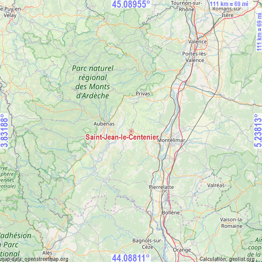
Saint-Jean-le-Centenier GPS coordinates[2]
44° 35' 27.564" North, 4° 32' 6" East
| Map corner | latitude | longitude |
|---|---|---|
| Upper-left | 45.08955°, | 3.83188° |
| Center: | 44.59099°, | 4.535° |
| Lower-right: | 44.08811°, | 5.23813° |
| Map W x H: | 111.3×111.3 km | = 69.2×69.2mi |
| max Lat: | 51.07786° ⇑82.9% North |
| Saint-Jean-le-Centenier: | 44.59099° |
| min Lat: | ⇓17.1% South 41.3874° |
| min Long | Saint-Jean-le-C | max Long |
| -5.08615° | 4.535° | 9.52242° |
| W 72.3%⇐ | ⇒27.7% E |
Elevation
Elevation of Saint-Jean-le-Centenier is 319 m = 1047 ft, and this is 125.3 m = 411 ft above average elevation for this country.
| Max E: |
2333 m = 7654 ft | 17.2% |
| Saint-Jean-le-Centenier | 319 m 1047 ft | |
| Avg. | 193.7 m = 635 ft | |
Min E: |
-1 m = -3 ft | 82.8% |
See also: France elevation on elevation.city.
Geographical zone
Saint-Jean-le-Centenier is located in North temperate zone (between Tropic of Cancer and the Arctic Circle). Distance of this Northern Tropic circle is 2352.1 km =1461.5 mi to South.| Distance of | km | miles | from Saint-Jean-le-Centenier |
|---|---|---|---|
| North Pole | 5049 | 3137.3 | to North |
| Arctic Circle | 2443.1 | 1518.1 | to North |
| Tropic Cancer | 2352.1 | 1461.5 | to South |
| Equator | 4958.1 | 3080.8 | to South |


Nearby cities:
15 places around Saint-Jean-le-Centenier: (largest is in red/bold)
• Alba-la-Romaine
6.4 km =4 mi,  128°
128°
• Aubenas
11.9 km =7.4 mi,  285°
285°
• Lavilledieu
6.7 km =4.2 mi,  255°
255°
• Le Teil
12.7 km =7.9 mi,  113°
113°
• Lussas
5.5 km =3.4 mi,  295°
295°
• Rochemaure
13.4 km =8.3 mi,  91°
91°
• Saint-Didier-sous-Aubenas
9.6 km =6 mi,  280°
280°
• Saint-Germain
7.8 km =4.8 mi,  238°
238°
• Saint-Julien-du-Serre
12.2 km =7.6 mi,  306°
306°
• Saint-Privat
10.4 km =6.5 mi, 293°
• Saint-Sernin
11.5 km =7.1 mi, 259°
• Saint-Étienne-de-Fontbellon
11.8 km =7.3 mi, 275°
• Vesseaux
10.1 km =6.3 mi, 311°
• Villeneuve-de-Berg
4.6 km =2.9 mi,  214°
214°
• Vogüé
10.5 km =6.5 mi, 244°
Sources, notices
• [Note1] Compared only with cities in France existing in our database
• [Src1] Map data: © OpenStreetMap contributors (CC-BY-SA)
• [Src2] Other city data from geonames.org with taken over terms of usage.
• [Src3] Geographical zone / Annual Mean Temperature by Robert A. Rohde @ Wikipedia
