Aubenas geodata
Aubenas (Auvergne-Rhône-Alpes) is a populated place; located in France in Europe/Paris (GMT+2) time zone. With population of 13,134 people, there are 724 cities with bigger population in this country. Compared to other cities in France, 82.6% of cities are located further ↑North; 71.3% of cities are located further ←West and 82.8% of cities have lower elevation than Aubenas. Note1
Administrative division(s):
- Level 1: Auvergne-Rhône-Alpes
- Level 2: Département de l'Ardèche
- Level 3: Arrondissement de Largentière
- Level 4: Aubenas


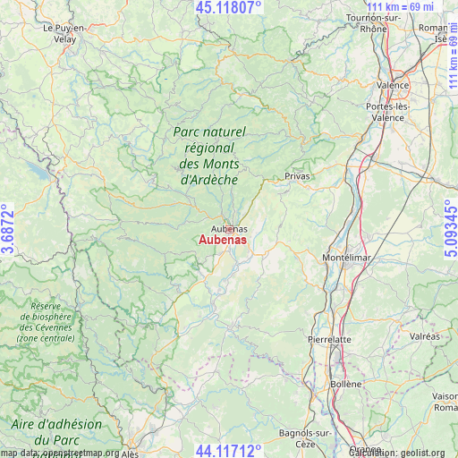
Aubenas GPS coordinates[2]
44° 37' 11.1" North, 4° 23' 25.188" East
| Map corner | latitude | longitude |
|---|---|---|
| Upper-left | 45.11807°, | 3.6872° |
| Center: | 44.61975°, | 4.39033° |
| Lower-right: | 44.11712°, | 5.09345° |
| Map W x H: | 111.3×111.3 km | = 69.2×69.2mi |
| max Lat: | 51.07786° ⇑82.6% North |
| Aubenas: | 44.61975° |
| min Lat: | ⇓17.4% South 41.3874° |
| min Long | Aubenas | max Long |
| -5.08615° | 4.39033° | 9.52242° |
| W 71.3%⇐ | ⇒28.7% E |
Elevation
Elevation of Aubenas is 320 m = 1050 ft, and this is 126.3 m = 414 ft above average elevation for this country.
| Max E: |
2333 m = 7654 ft | 17.2% |
| Aubenas | 320 m 1050 ft | |
| Avg. | 193.7 m = 635 ft | |
Min E: |
-1 m = -3 ft | 82.8% |
See also: France elevation on elevation.city.
Geographical zone
Aubenas is located in North temperate zone (between Tropic of Cancer and the Arctic Circle). Distance of this Northern Tropic circle is 2355.3 km =1463.5 mi to South.| Distance of | km | miles | from Aubenas |
|---|---|---|---|
| North Pole | 5045.8 | 3135.3 | to North |
| Arctic Circle | 2439.9 | 1516.1 | to North |
| Tropic Cancer | 2355.3 | 1463.5 | to South |
| Equator | 4961.3 | 3082.8 | to South |


Nearby cities:
15 places around Aubenas: (largest is in red/bold)
• Labégude
3.3 km =2.1 mi,  329°
329°
• Lachapelle-sous-Aubenas
6.5 km =4 mi,  198°
198°
• Lalevade-d’Ardèche
6.2 km =3.9 mi,  300°
300°
• Lavilledieu
7 km =4.3 mi,  134°
134°
• Lussas
6.6 km =4.1 mi,  97°
97°
• Prades
6.4 km =4 mi,  288°
288°
• Saint-Didier-sous-Aubenas
2.4 km =1.5 mi, 125°
• Saint-Germain
8.7 km =5.4 mi,  146°
146°
• Saint-Julien-du-Serre
4.4 km =2.7 mi,  22°
22°
• Saint-Privat
2.2 km =1.4 mi,  63°
63°
• Saint-Sernin
5.4 km =3.4 mi,  178°
178°
• Saint-Étienne-de-Fontbellon
2.1 km =1.3 mi,  188°
188°
• Vals-les-Bains
5.4 km =3.4 mi,  339°
339°
• Vesseaux
5.3 km =3.3 mi,  48°
48°
• Vogüé
7.9 km =4.9 mi,  166°
166°
Sources, notices
• [Note1] Compared only with cities in France existing in our database
• [Src1] Map data: © OpenStreetMap contributors (CC-BY-SA)
• [Src2] Other city data from geonames.org with taken over terms of usage.
• [Src3] Geographical zone / Annual Mean Temperature by Robert A. Rohde @ Wikipedia
