Saint-Jean-de-Luz geodata
Saint-Jean-de-Luz (Nouvelle-Aquitaine) is a populated place; located in France in Europe/Paris (GMT+2) time zone. With population of 14,514 people, there are 659 cities with bigger population in this country. Compared to other cities in France, 94.4% of cities are located further ↑North; 93.3% of cities are located further →East and 98.2% of cities have higher elevation than Saint-Jean-de-Luz. Note1
Administrative division(s):
- Level 1: Nouvelle-Aquitaine
- Level 2: Département des Pyrénées-Atlantiques
- Level 3: Arrondissement de Bayonne
- Level 4: Saint-Jean-de-Luz


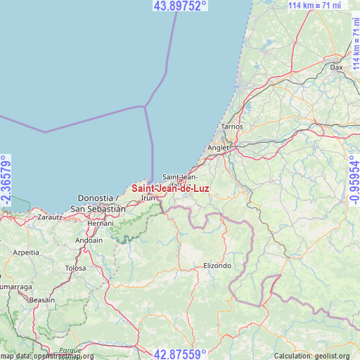
Saint-Jean-de-Luz GPS coordinates[2]
43° 23' 19.356" North, 1° 39' 45.612" West
| Map corner | latitude | longitude |
|---|---|---|
| Upper-left | 43.89752°, | -2.36579° |
| Center: | 43.38871°, | -1.66267° |
| Lower-right: | 42.87559°, | -0.95954° |
| Map W x H: | 113.6×113.6 km | = 70.6×70.6mi |
| max Lat: | 51.07786° ⇑94.4% North |
| Saint-Jean-de-Luz: | 43.38871° |
| min Lat: | ⇓5.6% South 41.3874° |
| min Long | Saint-Jean-de-L | max Long |
| -5.08615° | -1.66267° | 9.52242° |
| W 6.7%⇐ | ⇒93.3% E |
Elevation
Elevation of Saint-Jean-de-Luz is 8 m = 26 ft, and this is 185.7 m = 609 ft below average elevation for this country.
| Max E: |
2333 m = 7654 ft | 98.2% |
| Avg. | 193.7 m = 635 ft | |
| Saint-Jean-de-Luz | 8 m = 26 ft | |
Min E: |
-1 m = -3 ft | 1.8% |
See also: France elevation on elevation.city.
Geographical zone
Saint-Jean-de-Luz is located in North temperate zone (between Tropic of Cancer and the Arctic Circle). Distance of this Northern Tropic circle is 2218.5 km =1378.5 mi to South.| Distance of | km | miles | from Saint-Jean-de-Luz |
|---|---|---|---|
| North Pole | 5182.7 | 3220.4 | to North |
| Arctic Circle | 2576.8 | 1601.1 | to North |
| Tropic Cancer | 2218.5 | 1378.5 | to South |
| Equator | 4824.4 | 2997.7 | to South |


Nearby cities:
15 places around Saint-Jean-de-Luz: (largest is in red/bold)
• Ahetze
7.5 km =4.7 mi,  76°
76°
• Anglet
15.5 km =9.6 mi,  50°
50°
• Arbonne
10.2 km =6.3 mi,  61°
61°
• Arcangues
12.3 km =7.6 mi,  67°
67°
• Ascain
5.9 km =3.7 mi,  144°
144°
• Bassussarry
13.2 km =8.2 mi, 63°
• Biarritz
13.3 km =8.3 mi,  40°
40°
• Bidart
7.9 km =4.9 mi, 46°
• Biriatou
9 km =5.6 mi,  226°
226°
• Ciboure
1.3 km =0.8 mi,  238°
238°
• Guéthary
5.7 km =3.5 mi, 47°
• Hendaye
9.2 km =5.7 mi,  258°
258°
• Saint-Pée-sur-Nivelle
9.8 km =6.1 mi,  112°
112°
• Sare
10.8 km =6.7 mi, 141°
• Urrugne
4.1 km =2.5 mi, 226°
In other languages:
- In Spanish: San Juan de Luz, Donibane Lohizune
- In Russian: Сен-Жан-де-Люз
- In Chinese: 圣让德吕
Sources, notices
• [Note1] Compared only with cities in France existing in our database
• [Src1] Map data: © OpenStreetMap contributors (CC-BY-SA)
• [Src2] Other city data from geonames.org with taken over terms of usage.
• [Src3] Geographical zone / Annual Mean Temperature by Robert A. Rohde @ Wikipedia
