Anglet geodata
Anglet (Nouvelle-Aquitaine) is a populated place; located in France in Europe/Paris (GMT+2) time zone. With population of 40,658 people, there are 178 cities with bigger population in this country. Compared to other cities in France, 93.4% of cities are located further ↑North; 92.4% of cities are located further →East and 92% of cities have higher elevation than Anglet. Note1
Administrative division(s):
- Level 1: Nouvelle-Aquitaine
- Level 2: Département des Pyrénées-Atlantiques
- Level 3: Arrondissement de Bayonne
- Level 4: Anglet


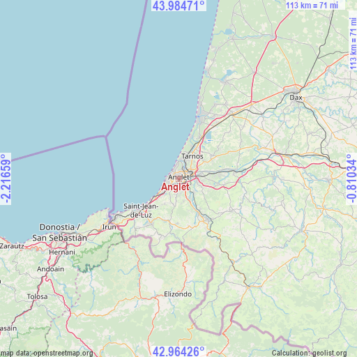
Anglet GPS coordinates[2]
43° 28' 35.904" North, 1° 30' 48.456" West
| Map corner | latitude | longitude |
|---|---|---|
| Upper-left | 43.98471°, | -2.21659° |
| Center: | 43.47664°, | -1.51346° |
| Lower-right: | 42.96426°, | -0.81034° |
| Map W x H: | 113.5×113.5 km | = 70.5×70.5mi |
| max Lat: | 51.07786° ⇑93.4% North |
| Anglet: | 43.47664° |
| min Lat: | ⇓6.6% South 41.3874° |
| min Long | Anglet | max Long |
| -5.08615° | -1.51346° | 9.52242° |
| W 7.6%⇐ | ⇒92.4% E |
Elevation
Elevation of Anglet is 25 m = 82 ft, and this is 168.7 m = 553 ft below average elevation for this country.
| Max E: |
2333 m = 7654 ft | 92% |
| Avg. | 193.7 m = 635 ft | |
| Anglet | 25 m = 82 ft | |
Min E: |
-1 m = -3 ft | 8% |
See also: Anglet elevation on elevation.city.
Geographical zone
Anglet is located in North temperate zone (between Tropic of Cancer and the Arctic Circle). Distance of this Northern Tropic circle is 2228.2 km =1384.5 mi to South.| Distance of | km | miles | from Anglet |
|---|---|---|---|
| North Pole | 5172.9 | 3214.3 | to North |
| Arctic Circle | 2567 | 1595.1 | to North |
| Tropic Cancer | 2228.2 | 1384.5 | to South |
| Equator | 4834.1 | 3003.8 | to South |


Nearby cities:
15 places around Anglet: (largest is in red/bold)
• Ahetze
9.3 km =5.8 mi,  210°
210°
• Arbonne
5.8 km =3.6 mi, 211°
• Arcangues
5.1 km =3.2 mi,  188°
188°
• Bassussarry
3.8 km =2.4 mi,  183°
183°
• Bayonne
3.5 km =2.2 mi,  59°
59°
• Biarritz
3.4 km =2.1 mi,  276°
276°
• Bidart
7.6 km =4.7 mi,  235°
235°
• Boucau
6.9 km =4.3 mi,  34°
34°
• Guéthary
9.9 km =6.2 mi,  232°
232°
• Lahonce
9.9 km =6.2 mi,  86°
86°
• Mouguerre
7.7 km =4.8 mi,  97°
97°
• Ondres
11.3 km =7 mi, 29°
• Tarnos
8.3 km =5.2 mi, 29°
• Ustaritz
10 km =6.2 mi,  152°
152°
• Villefranque
6.6 km =4.1 mi,  132°
132°
Sources, notices
• [Note1] Compared only with cities in France existing in our database
• [Src1] Map data: © OpenStreetMap contributors (CC-BY-SA)
• [Src2] Other city data from geonames.org with taken over terms of usage.
• [Src3] Geographical zone / Annual Mean Temperature by Robert A. Rohde @ Wikipedia
