Ahetze geodata
Ahetze (Nouvelle-Aquitaine) is a populated place; located in France in Europe/Paris (GMT+2) time zone. With population of 1,422 people, there are 6513 cities with bigger population in this country. Compared to other cities in France, 94.2% of cities are located further ↑North; 92.8% of cities are located further →East and 92.4% of cities have higher elevation than Ahetze. Note1
Administrative division(s):
- Level 1: Nouvelle-Aquitaine
- Level 2: Département des Pyrénées-Atlantiques
- Level 3: Arrondissement de Bayonne
- Level 4: Ahetze


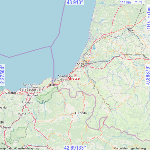
Ahetze GPS coordinates[2]
43° 24' 15.552" North, 1° 34' 18.876" West
| Map corner | latitude | longitude |
|---|---|---|
| Upper-left | 43.913°, | -2.27504° |
| Center: | 43.40432°, | -1.57191° |
| Lower-right: | 42.89133°, | -0.86879° |
| Map W x H: | 113.6×113.6 km | = 70.6×70.6mi |
| max Lat: | 51.07786° ⇑94.2% North |
| Ahetze: | 43.40432° |
| min Lat: | ⇓5.8% South 41.3874° |
| min Long | Ahetze | max Long |
| -5.08615° | -1.57191° | 9.52242° |
| W 7.2%⇐ | ⇒92.8% E |
Elevation
Elevation of Ahetze is 24 m = 79 ft, and this is 169.7 m = 557 ft below average elevation for this country.
| Max E: |
2333 m = 7654 ft | 92.4% |
| Avg. | 193.7 m = 635 ft | |
| Ahetze | 24 m = 79 ft | |
Min E: |
-1 m = -3 ft | 7.6% |
See also: France elevation on elevation.city.
Geographical zone
Ahetze is located in North temperate zone (between Tropic of Cancer and the Arctic Circle). Distance of this Northern Tropic circle is 2220.2 km =1379.6 mi to South.| Distance of | km | miles | from Ahetze |
|---|---|---|---|
| North Pole | 5181 | 3219.3 | to North |
| Arctic Circle | 2575.1 | 1600.1 | to North |
| Tropic Cancer | 2220.2 | 1379.6 | to South |
| Equator | 4826.1 | 2998.8 | to South |


Nearby cities:
15 places around Ahetze: (largest is in red/bold)
• Anglet
9.3 km =5.8 mi,  30°
30°
• Arbonne
3.6 km =2.2 mi, 28°
• Arcangues
5 km =3.1 mi,  53°
53°
• Ascain
7.7 km =4.8 mi,  210°
210°
• Bassussarry
6.2 km =3.9 mi, 46°
• Biarritz
8.5 km =5.3 mi,  8°
8°
• Bidart
4 km =2.5 mi,  337°
337°
• Ciboure
8.7 km =5.4 mi,  254°
254°
• Guéthary
3.8 km =2.4 mi,  303°
303°
• Saint-Jean-de-Luz
7.5 km =4.7 mi,  256°
256°
• Saint-Pée-sur-Nivelle
5.7 km =3.5 mi,  161°
161°
• Sare
10.2 km =6.3 mi,  183°
183°
• Souraïde
10.5 km =6.5 mi,  131°
131°
• Ustaritz
9.4 km =5.8 mi,  95°
95°
• Villefranque
10.2 km =6.3 mi,  69°
69°
Sources, notices
• [Note1] Compared only with cities in France existing in our database
• [Src1] Map data: © OpenStreetMap contributors (CC-BY-SA)
• [Src2] Other city data from geonames.org with taken over terms of usage.
• [Src3] Geographical zone / Annual Mean Temperature by Robert A. Rohde @ Wikipedia
