Saint-Hilaire-sur-Helpe geodata
Saint-Hilaire-sur-Helpe (Hauts-de-France) is a populated place; located in France in Europe/Paris (GMT+2) time zone. With population of 836 people, there are 10228 cities with bigger population in this country. Compared to other cities in France, 94.4% of cities are located further ↓South; 67% of cities are located further ←West and 55.9% of cities have lower elevation than Saint-Hilaire-sur-Helpe. Note1
Administrative division(s):
- Level 1: Hauts-de-France
- Level 2: Nord
- Level 3: Avesnes-sur-Helpe
- Level 4: Saint-Hilaire-sur-Helpe
Current local time in Saint-Hilaire-sur-Helpe:
11:04 PM, FridayDifference from your time zone: hours


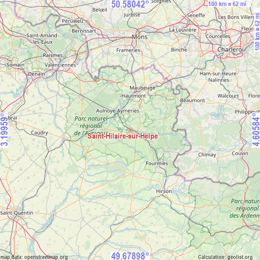
Saint-Hilaire-sur-Helpe GPS coordinates[2]
50° 7' 54.552" North, 3° 54' 9.756" East
| Map corner | latitude | longitude |
|---|---|---|
| Upper-left | 50.58042°, | 3.19959° |
| Center: | 50.13182°, | 3.90271° |
| Lower-right: | 49.67898°, | 4.60584° |
| Map W x H: | 100.2×100.2 km | = 62.3×62.3mi |
| max Lat: | 51.07786° ⇑5.6% North |
| Saint-Hilaire-sur-Helpe: | 50.13182° |
| min Lat: | ⇓94.4% South 41.3874° |
| min Long | Saint-Hilaire-s | max Long |
| -5.08615° | 3.90271° | 9.52242° |
| W 67%⇐ | ⇒33% E |
Elevation
Elevation of Saint-Hilaire-sur-Helpe is 153 m = 502 ft, and this is 40.7 m = 134 ft below average elevation for this country.
| Max E: |
2333 m = 7654 ft | 44.1% |
| Avg. | 193.7 m = 635 ft | |
| Saint-Hilaire-sur-Helpe | 153 m = 502 ft | |
Min E: |
-1 m = -3 ft | 55.9% |
See also: France elevation on elevation.city.
Geographical zone
Saint-Hilaire-sur-Helpe is located in North temperate zone (between Tropic of Cancer and the Arctic Circle). Distance of this North polar circle is 1827 km =1135.2 mi to North.| Distance of | km | miles | from Saint-Hilaire-sur-Helpe |
|---|---|---|---|
| North Pole | 4432.9 | 2754.5 | to North |
| Arctic Circle | 1827 | 1135.2 | to North |
| Tropic Cancer | 2968.2 | 1844.4 | to South |
| Equator | 5574.1 | 3463.6 | to South |


Nearby cities:
15 places around Saint-Hilaire-sur-Helpe: (largest is in red/bold)
• Aulnoye-Aymeries
9 km =5.6 mi,  329°
329°
• Avesnelles
3.5 km =2.2 mi,  116°
116°
• Avesnes-sur-Helpe
1.9 km =1.2 mi, 118°
• Bachant
9.6 km =6 mi,  345°
345°
• Berlaimont
10 km =6.2 mi,  320°
320°
• Cartignies
6 km =3.7 mi,  223°
223°
• Dompierre-sur-Helpe
3 km =1.9 mi,  292°
292°
• Floyon
10 km =6.2 mi,  186°
186°
• Leval
7.5 km =4.7 mi, 316°
• Maroilles
10.1 km =6.3 mi,  272°
272°
• Monceau-Saint-Waast
5.6 km =3.5 mi, 320°
• Pont-sur-Sambre
10.8 km =6.7 mi,  338°
338°
• Sains-du-Nord
8.7 km =5.4 mi, 119°
• Sars-Poteries
9.8 km =6.1 mi,  64°
64°
• Taisnières-en-Thiérache
6.5 km =4 mi, 285°
Sources, notices
• [Note1] Compared only with cities in France existing in our database
• [Src1] Map data: © OpenStreetMap contributors (CC-BY-SA)
• [Src2] Other city data from geonames.org with taken over terms of usage.
• [Src3] Geographical zone / Annual Mean Temperature by Robert A. Rohde @ Wikipedia
