Avesnelles geodata
Avesnelles (Hauts-de-France) is a populated place; located in France in Europe/Paris (GMT+2) time zone. With population of 2,643 people, there are 3686 cities with bigger population in this country. Compared to other cities in France, 94.3% of cities are located further ↓South; 67.3% of cities are located further ←West and 58.7% of cities have lower elevation than Avesnelles. Note1
Administrative division(s):
- Level 1: Hauts-de-France
- Level 2: Nord
- Level 3: Avesnes-sur-Helpe
- Level 4: Avesnelles


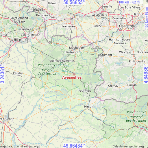
Avesnelles GPS coordinates[2]
50° 7' 4.152" North, 3° 56' 48.264" East
| Map corner | latitude | longitude |
|---|---|---|
| Upper-left | 50.56655°, | 3.24361° |
| Center: | 50.11782°, | 3.94674° |
| Lower-right: | 49.66484°, | 4.64986° |
| Map W x H: | 100.3×100.3 km | = 62.3×62.3mi |
| max Lat: | 51.07786° ⇑5.7% North |
| Avesnelles: | 50.11782° |
| min Lat: | ⇓94.3% South 41.3874° |
| min Long | Avesnelles | max Long |
| -5.08615° | 3.94674° | 9.52242° |
| W 67.3%⇐ | ⇒32.7% E |
Elevation
Elevation of Avesnelles is 164 m = 538 ft, and this is 29.7 m = 97 ft below average elevation for this country.
| Max E: |
2333 m = 7654 ft | 41.3% |
| Avg. | 193.7 m = 635 ft | |
| Avesnelles | 164 m = 538 ft | |
Min E: |
-1 m = -3 ft | 58.7% |
See also: France elevation on elevation.city.
Geographical zone
Avesnelles is located in North temperate zone (between Tropic of Cancer and the Arctic Circle). Distance of this North polar circle is 1828.6 km =1136.2 mi to North.| Distance of | km | miles | from Avesnelles |
|---|---|---|---|
| North Pole | 4434.5 | 2755.5 | to North |
| Arctic Circle | 1828.6 | 1136.2 | to North |
| Tropic Cancer | 2966.7 | 1843.4 | to South |
| Equator | 5572.6 | 3462.7 | to South |


Nearby cities:
15 places around Avesnelles: (largest is in red/bold)
• Aulnoye-Aymeries
12.1 km =7.5 mi,  320°
320°
• Avesnes-sur-Helpe
1.6 km =1 mi,  293°
293°
• Bachant
12.2 km =7.6 mi,  332°
332°
• Cartignies
7.8 km =4.8 mi,  249°
249°
• Dompierre-sur-Helpe
6.5 km =4 mi, 294°
• Floyon
9.4 km =5.8 mi,  207°
207°
• Leval
10.8 km =6.7 mi,  310°
310°
• Monceau-Saint-Waast
8.9 km =5.5 mi, 311°
• Sains-du-Nord
5.2 km =3.2 mi,  121°
121°
• Saint-Hilaire-sur-Helpe
3.5 km =2.2 mi,  296°
296°
• Sars-Poteries
8.1 km =5 mi,  44°
44°
• Solre-le-Château
11.9 km =7.4 mi,  58°
58°
• Taisnières-en-Thiérache
10 km =6.2 mi, 289°
• Trélon
12.9 km =8 mi, 120°
• Wignehies
12.2 km =7.6 mi,  158°
158°
Sources, notices
• [Note1] Compared only with cities in France existing in our database
• [Src1] Map data: © OpenStreetMap contributors (CC-BY-SA)
• [Src2] Other city data from geonames.org with taken over terms of usage.
• [Src3] Geographical zone / Annual Mean Temperature by Robert A. Rohde @ Wikipedia
