Saint-Goazec geodata
Saint-Goazec (Brittany) is a populated place; located in France in Europe/Paris (GMT+2) time zone. With population of 785 people, there are 10762 cities with bigger population in this country. Compared to other cities in France, 62.2% of cities are located further ↓South; 98.7% of cities are located further →East and 53.1% of cities have higher elevation than Saint-Goazec. Note1
Administrative division(s):
- Level 1: Brittany
- Level 2: Département du Finistère
- Level 3: Arrondissement de Châteaulin
- Level 4: Saint-Goazec


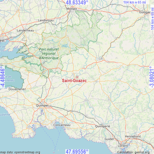
Saint-Goazec GPS coordinates[2]
48° 10' 0.012" North, 3° 46' 59.988" West
| Map corner | latitude | longitude |
|---|---|---|
| Upper-left | 48.63349°, | -4.48646° |
| Center: | 48.16667°, | -3.78333° |
| Lower-right: | 47.69556°, | -3.08021° |
| Map W x H: | 104.3×104.3 km | = 64.8×64.8mi |
| max Lat: | 51.07786° ⇑37.8% North |
| Saint-Goazec: | 48.16667° |
| min Lat: | ⇓62.2% South 41.3874° |
| min Long | Saint-Goazec | max Long |
| -5.08615° | -3.78333° | 9.52242° |
| W 1.3%⇐ | ⇒98.7% E |
Elevation
Elevation of Saint-Goazec is 122 m = 400 ft, and this is 71.7 m = 235 ft below average elevation for this country.
| Max E: |
2333 m = 7654 ft | 53.1% |
| Avg. | 193.7 m = 635 ft | |
| Saint-Goazec | 122 m = 400 ft | |
Min E: |
-1 m = -3 ft | 46.9% |
See also: France elevation on elevation.city.
Geographical zone
Saint-Goazec is located in North temperate zone (between Tropic of Cancer and the Arctic Circle). Distance of this North polar circle is 2045.5 km =1271 mi to North.| Distance of | km | miles | from Saint-Goazec |
|---|---|---|---|
| North Pole | 4651.4 | 2890.2 | to North |
| Arctic Circle | 2045.5 | 1271 | to North |
| Tropic Cancer | 2749.7 | 1708.6 | to South |
| Equator | 5355.6 | 3327.8 | to South |


Nearby cities:
15 places around Saint-Goazec: (largest is in red/bold)
• Châteauneuf-du-Faou
3.5 km =2.2 mi,  312°
312°
• Cléden-Poher
11.5 km =7.1 mi,  47°
47°
• Collorec
13.2 km =8.2 mi,  2°
2°
• Coray
12.4 km =7.7 mi,  196°
196°
• Landeleau
7.9 km =4.9 mi,  31°
31°
• Laz
5 km =3.1 mi,  230°
230°
• Le Cloître-Pleyben
12.9 km =8 mi,  321°
321°
• Lennon
8.9 km =5.5 mi,  288°
288°
• Leuhan
7.5 km =4.7 mi,  180°
180°
• Plonévez-du-Faou
10 km =6.2 mi,  338°
338°
• Roudouallec
6.2 km =3.9 mi,  126°
126°
• Saint-Hernin
12.4 km =7.7 mi,  63°
63°
• Saint-Thois
7.4 km =4.6 mi,  270°
270°
• Spézet
6.2 km =3.9 mi, 53°
• Trégourez
9.7 km =6 mi,  219°
219°
Sources, notices
• [Note1] Compared only with cities in France existing in our database
• [Src1] Map data: © OpenStreetMap contributors (CC-BY-SA)
• [Src2] Other city data from geonames.org with taken over terms of usage.
• [Src3] Geographical zone / Annual Mean Temperature by Robert A. Rohde @ Wikipedia
