Sainte-Hélène-sur-Isère geodata
Sainte-Hélène-sur-Isère (Auvergne-Rhône-Alpes) is a populated place; located in France in Europe/Paris (GMT+2) time zone. With population of 1,074 people, there are 8304 cities with bigger population in this country. Compared to other cities in France, 72.4% of cities are located further ↑North; 90.4% of cities are located further ←West and 88.9% of cities have lower elevation than Sainte-Hélène-sur-Isère. Note1
Administrative division(s):
- Level 1: Auvergne-Rhône-Alpes
- Level 2: Savoie
- Level 3: Albertville
- Level 4: Sainte-Hélène-sur-Isère
Current local time in Sainte-Hélène-sur-Isère:
01:45 PM, WednesdayDifference from your time zone: hours


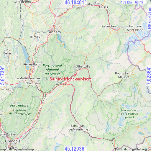
Sainte-Hélène-sur-Isère GPS coordinates[2]
45° 36' 51.624" North, 6° 19' 13.872" East
| Map corner | latitude | longitude |
|---|---|---|
| Upper-left | 46.10401°, | 5.61739° |
| Center: | 45.61434°, | 6.32052° |
| Lower-right: | 45.12036°, | 7.02364° |
| Map W x H: | 109.4×109.4 km | = 68×68mi |
| max Lat: | 51.07786° ⇑72.4% North |
| Sainte-Hélène-sur-Isère: | 45.61434° |
| min Lat: | ⇓27.6% South 41.3874° |
| min Long | Sainte-Hélène | max Long |
| -5.08615° | 6.32052° | 9.52242° |
| W 90.4%⇐ | ⇒9.6% E |
Elevation
Elevation of Sainte-Hélène-sur-Isère is 405 m = 1329 ft, and this is 211.3 m = 693 ft above average elevation for this country.
| Max E: |
2333 m = 7654 ft | 11.1% |
| Sainte-Hélène-sur-Isère | 405 m 1329 ft | |
| Avg. | 193.7 m = 635 ft | |
Min E: |
-1 m = -3 ft | 88.9% |
See also: France elevation on elevation.city.
Geographical zone
Sainte-Hélène-sur-Isère is located in North temperate zone (between Tropic of Cancer and the Arctic Circle). Distance of this North polar circle is 2329.3 km =1447.4 mi to North.| Distance of | km | miles | from Sainte-Hélène-sur-Isère |
|---|---|---|---|
| North Pole | 4935.2 | 3066.6 | to North |
| Arctic Circle | 2329.3 | 1447.4 | to North |
| Tropic Cancer | 2465.9 | 1532.2 | to South |
| Equator | 5071.8 | 3151.5 | to South |


Nearby cities:
15 places around Sainte-Hélène-sur-Isère: (largest is in red/bold)
• Aiguebelle
7.9 km =4.9 mi,  189°
189°
• Aiton
7.6 km =4.7 mi,  218°
218°
• Albertville
8.6 km =5.3 mi,  39°
39°
• Esserts-Blay
9 km =5.6 mi,  90°
90°
• Frontenex
2.2 km =1.4 mi,  341°
341°
• Gilly-sur-Isère
5.5 km =3.4 mi,  25°
25°
• Grignon
6.1 km =3.8 mi,  47°
47°
• Grésy-sur-Isère
5.5 km =3.4 mi,  251°
251°
• Mercury
6.8 km =4.2 mi,  10°
10°
• Montailleur
3.4 km =2.1 mi,  275°
275°
• Notre-Dame-des-Millières
1.6 km =1 mi,  55°
55°
• Pallud
9.4 km =5.8 mi, 34°
• Randens
7.6 km =4.7 mi, 186°
• Saint-Vital
2.2 km =1.4 mi,  312°
312°
• Verrens
4.5 km =2.8 mi,  357°
357°
Sources, notices
• [Note1] Compared only with cities in France existing in our database
• [Src1] Map data: © OpenStreetMap contributors (CC-BY-SA)
• [Src2] Other city data from geonames.org with taken over terms of usage.
• [Src3] Geographical zone / Annual Mean Temperature by Robert A. Rohde @ Wikipedia
