Randens geodata
Randens (Auvergne-Rhône-Alpes) is a populated place; located in France in Europe/Paris (GMT+2) time zone. With population of 727 people, there are 11442 cities with bigger population in this country. Compared to other cities in France, 73.5% of cities are located further ↑North; 90.3% of cities are located further ←West and 95.4% of cities have lower elevation than Randens. Note1
Administrative division(s):
- Level 1: Auvergne-Rhône-Alpes
- Level 2: Savoie
- Level 3: Arrondissement de Saint-Jean-de-Maurienne
- Level 4: Val-d'Arc


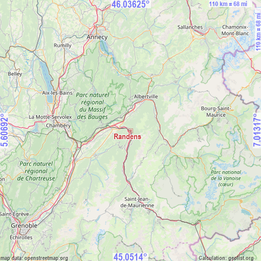
Randens GPS coordinates[2]
45° 32' 45.528" North, 6° 18' 36.144" East
| Map corner | latitude | longitude |
|---|---|---|
| Upper-left | 46.03625°, | 5.60692° |
| Center: | 45.54598°, | 6.31004° |
| Lower-right: | 45.0514°, | 7.01317° |
| Map W x H: | 109.5×109.5 km | = 68×68mi |
| max Lat: | 51.07786° ⇑73.5% North |
| Randens: | 45.54598° |
| min Lat: | ⇓26.5% South 41.3874° |
| min Long | Randens | max Long |
| -5.08615° | 6.31004° | 9.52242° |
| W 90.3%⇐ | ⇒9.7% E |
Elevation
Elevation of Randens is 606 m = 1988 ft, and this is 412.3 m = 1353 ft above average elevation for this country.
| Max E: |
2333 m = 7654 ft | 4.6% |
| Randens | 606 m 1988 ft | |
| Avg. | 193.7 m = 635 ft | |
Min E: |
-1 m = -3 ft | 95.4% |
See also: France elevation on elevation.city.
Geographical zone
Randens is located in North temperate zone (between Tropic of Cancer and the Arctic Circle). Distance of this North polar circle is 2336.9 km =1452.1 mi to North.| Distance of | km | miles | from Randens |
|---|---|---|---|
| North Pole | 4942.8 | 3071.3 | to North |
| Arctic Circle | 2336.9 | 1452.1 | to North |
| Tropic Cancer | 2458.3 | 1527.5 | to South |
| Equator | 5064.2 | 3146.7 | to South |


Nearby cities:
15 places around Randens: (largest is in red/bold)
• Aiguebelle
0.5 km =0.3 mi,  244°
244°
• Aiton
4.3 km =2.7 mi,  293°
293°
• Argentine
5.8 km =3.6 mi,  177°
177°
• Cevins
12.3 km =7.6 mi,  65°
65°
• Chamoux-sur-Gelon
7.6 km =4.7 mi,  259°
259°
• Châteauneuf
10.7 km =6.6 mi,  271°
271°
• Frontenex
9.7 km =6 mi,  0°
0°
• Grésy-sur-Isère
7.4 km =4.6 mi,  323°
323°
• Montailleur
8.3 km =5.2 mi,  342°
342°
• Notre-Dame-des-Millières
8.8 km =5.5 mi,  14°
14°
• Saint-Paul-sur-Isère
11.6 km =7.2 mi,  59°
59°
• Saint-Vital
9.2 km =5.7 mi,  354°
354°
• Sainte-Hélène-sur-Isère
7.6 km =4.7 mi, 6°
• Verrens
12.2 km =7.6 mi, 2°
• Épierre
10.4 km =6.5 mi,  186°
186°
Sources, notices
• [Note1] Compared only with cities in France existing in our database
• [Src1] Map data: © OpenStreetMap contributors (CC-BY-SA)
• [Src2] Other city data from geonames.org with taken over terms of usage.
• [Src3] Geographical zone / Annual Mean Temperature by Robert A. Rohde @ Wikipedia
