Sainte-Florence geodata
Sainte-Florence (Pays de la Loire) is a populated place; located in France in Europe/Paris (GMT+2) time zone. With population of 915 people, there are 9526 cities with bigger population in this country. Compared to other cities in France, 57.2% of cities are located further ↑North; 89.6% of cities are located further →East and 60% of cities have higher elevation than Sainte-Florence. Note1
Administrative division(s):
- Level 1: Pays de la Loire
- Level 2: Département de la Vendée
- Level 3: Arrondissement de La Roche-sur-Yon
- Level 4: Essarts en Bocage


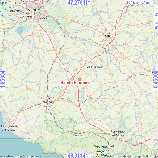
Sainte-Florence GPS coordinates[2]
46° 47' 48.876" North, 1° 9' 11.556" West
| Map corner | latitude | longitude |
|---|---|---|
| Upper-left | 47.27611°, | -1.85634° |
| Center: | 46.79691°, | -1.15321° |
| Lower-right: | 46.31341°, | -0.45009° |
| Map W x H: | 107×107 km | = 66.5×66.5mi |
| max Lat: | 51.07786° ⇑57.2% North |
| Sainte-Florence: | 46.79691° |
| min Lat: | ⇓42.8% South 41.3874° |
| min Long | Sainte-Florence | max Long |
| -5.08615° | -1.15321° | 9.52242° |
| W 10.4%⇐ | ⇒89.6% E |
Elevation
Elevation of Sainte-Florence is 102 m = 335 ft, and this is 91.7 m = 301 ft below average elevation for this country.
| Max E: |
2333 m = 7654 ft | 60% |
| Avg. | 193.7 m = 635 ft | |
| Sainte-Florence | 102 m = 335 ft | |
Min E: |
-1 m = -3 ft | 40% |
See also: France elevation on elevation.city.
Geographical zone
Sainte-Florence is located in North temperate zone (between Tropic of Cancer and the Arctic Circle). Distance of this North polar circle is 2197.8 km =1365.6 mi to North.| Distance of | km | miles | from Sainte-Florence |
|---|---|---|---|
| North Pole | 4803.7 | 2984.9 | to North |
| Arctic Circle | 2197.8 | 1365.6 | to North |
| Tropic Cancer | 2597.4 | 1613.9 | to South |
| Equator | 5203.3 | 3233.2 | to South |


Nearby cities:
15 places around Sainte-Florence: (largest is in red/bold)
• Bazoges-en-Paillers
12.4 km =7.7 mi,  6°
6°
• Boulogne
12.7 km =7.9 mi,  268°
268°
• Chauché
9.7 km =6 mi,  291°
291°
• La Merlatière
11.7 km =7.3 mi,  254°
254°
• La Rabatelière
10.9 km =6.8 mi,  311°
311°
• Les Essarts
6.2 km =3.9 mi, 246°
• Mesnard-la-Barotière
8 km =5 mi,  31°
31°
• Mouchamps
7.2 km =4.5 mi,  103°
103°
• Rochetrejoux
12 km =7.5 mi,  93°
93°
• Saint-Fulgent
6.4 km =4 mi,  342°
342°
• Saint-Hilaire-le-Vouhis
12.2 km =7.6 mi,  171°
171°
• Saint-Martin-des-Noyers
8.5 km =5.3 mi,  192°
192°
• Saint-Vincent-Sterlanges
8 km =5 mi,  141°
141°
• Sainte-Cécile
6.7 km =4.2 mi,  153°
153°
• Vendrennes
3.9 km =2.4 mi,  35°
35°
Sources, notices
• [Note1] Compared only with cities in France existing in our database
• [Src1] Map data: © OpenStreetMap contributors (CC-BY-SA)
• [Src2] Other city data from geonames.org with taken over terms of usage.
• [Src3] Geographical zone / Annual Mean Temperature by Robert A. Rohde @ Wikipedia
