Sainte-Cécile geodata
Sainte-Cécile (Pays de la Loire) is a populated place; located in France in Europe/Paris (GMT+2) time zone. With population of 1,437 people, there are 6447 cities with bigger population in this country. Compared to other cities in France, 57.8% of cities are located further ↑North; 89.3% of cities are located further →East and 80.2% of cities have higher elevation than Sainte-Cécile. Note1
Administrative division(s):
- Level 1: Pays de la Loire
- Level 2: Département de la Vendée
- Level 3: Arrondissement de La Roche-sur-Yon
- Level 4: Sainte-Cécile


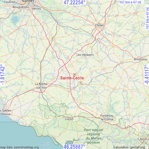
Sainte-Cécile GPS coordinates[2]
46° 44' 34.296" North, 1° 6' 51.444" West
| Map corner | latitude | longitude |
|---|---|---|
| Upper-left | 47.22254°, | -1.81742° |
| Center: | 46.74286°, | -1.11429° |
| Lower-right: | 46.25887°, | -0.41117° |
| Map W x H: | 107.2×107.1 km | = 66.6×66.5mi |
| max Lat: | 51.07786° ⇑57.8% North |
| Sainte-Cécile: | 46.74286° |
| min Lat: | ⇓42.2% South 41.3874° |
| min Long | Sainte-Cécile | max Long |
| -5.08615° | -1.11429° | 9.52242° |
| W 10.7%⇐ | ⇒89.3% E |
Elevation
Elevation of Sainte-Cécile is 54 m = 177 ft, and this is 139.7 m = 458 ft below average elevation for this country.
| Max E: |
2333 m = 7654 ft | 80.2% |
| Avg. | 193.7 m = 635 ft | |
| Sainte-Cécile | 54 m = 177 ft | |
Min E: |
-1 m = -3 ft | 19.8% |
See also: France elevation on elevation.city.
Geographical zone
Sainte-Cécile is located in North temperate zone (between Tropic of Cancer and the Arctic Circle). Distance of this North polar circle is 2203.9 km =1369.4 mi to North.| Distance of | km | miles | from Sainte-Cécile |
|---|---|---|---|
| North Pole | 4809.7 | 2988.6 | to North |
| Arctic Circle | 2203.9 | 1369.4 | to North |
| Tropic Cancer | 2591.4 | 1610.2 | to South |
| Equator | 5197.3 | 3229.5 | to South |


Nearby cities:
15 places around Sainte-Cécile: (largest is in red/bold)
• Bournezeau
12.5 km =7.8 mi,  200°
200°
• Chantonnay
7.9 km =4.9 mi,  141°
141°
• Les Essarts
9.4 km =5.8 mi,  291°
291°
• Mesnard-la-Barotière
12.9 km =8 mi,  5°
5°
• Monsireigne
12.6 km =7.8 mi,  89°
89°
• Mouchamps
5.9 km =3.7 mi,  43°
43°
• Rochetrejoux
10.4 km =6.5 mi,  60°
60°
• Saint-Germain-de-Prinçay
7.5 km =4.7 mi,  108°
108°
• Saint-Hilaire-le-Vouhis
6.2 km =3.9 mi,  191°
191°
• Saint-Martin-des-Noyers
5.3 km =3.3 mi,  244°
244°
• Saint-Prouant
12.1 km =7.5 mi,  81°
81°
• Saint-Vincent-Sterlanges
2 km =1.2 mi,  98°
98°
• Sainte-Florence
6.7 km =4.2 mi,  333°
333°
• Sigournais
10.6 km =6.6 mi, 112°
• Vendrennes
9.2 km =5.7 mi,  355°
355°
Sources, notices
• [Note1] Compared only with cities in France existing in our database
• [Src1] Map data: © OpenStreetMap contributors (CC-BY-SA)
• [Src2] Other city data from geonames.org with taken over terms of usage.
• [Src3] Geographical zone / Annual Mean Temperature by Robert A. Rohde @ Wikipedia
